Flagler Beach geodata
Flagler Beach (Florida) is a populated place; located in United States in America/New_York (GMT-4) time zone. With population of 4,869 people, there are 7297 cities with bigger population in this country. Compared to other cities in United States, 94.7% of cities are located further ↑North; 69.1% of cities are located further ←West and 98.1% of cities have higher elevation than Flagler Beach. Note1


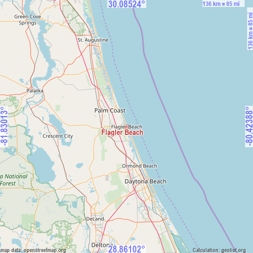
Flagler Beach GPS coordinates[2]
29° 28' 29.928" North, 81° 7' 37.2" West
| Map corner | latitude | longitude |
|---|---|---|
| Upper-left | 30.08524°, | -81.83013° |
| Center: | 29.47498°, | -81.127° |
| Lower-right: | 28.86102°, | -80.42388° |
| Map W x H: | 136.1×136.1 km | = 84.6×84.6mi |
| max Lat: | 71.29058° ⇑94.7% North |
| Flagler Beach: | 29.47498° |
| min Lat: | ⇓5.3% South 19.06759° |
| min Long | Flagler Beach | max Long |
| -171.73463° | -81.127° | -66.98998° |
| W 69.1%⇐ | ⇒30.9% E |
Elevation
Elevation of Flagler Beach is 5 m = 16 ft, and this is 289.8 m = 951 ft below average elevation for this country.
| Max E: |
3189 m = 10463 ft | 98.1% |
| Avg. | 294.8 m = 967 ft | |
| Flagler Beach | 5 m = 16 ft | |
Min E: |
-60 m = -197 ft | 1.9% |
See also: United States elevation on elevation.city.
Geographical zone
Flagler Beach is located in North temperate zone (between Tropic of Cancer and the Arctic Circle). Distance of this Northern Tropic circle is 671.4 km =417.2 mi to South.| Distance of | km | miles | from Flagler Beach |
|---|---|---|---|
| North Pole | 6729.8 | 4181.7 | to North |
| Arctic Circle | 4123.9 | 2562.5 | to North |
| Tropic Cancer | 671.4 | 417.2 | to South |
| Equator | 3277.3 | 2036.4 | to South |


Nearby cities:
15 places around Flagler Beach: (largest is in red/bold)
• Bunnell
12.7 km =7.9 mi,  265°
265°
• Butler Beach
38.4 km =23.9 mi,  339°
339°
• Crescent Beach
34.9 km =21.7 mi, 339°
• Crescent City
37.5 km =23.3 mi,  262°
262°
• Daytona Beach
31.1 km =19.3 mi,  161°
161°
• Daytona Beach Shores
36.1 km =22.4 mi, 157°
• Flagler Estates
37.1 km =23.1 mi,  300°
300°
• Holly Hill
27.1 km =16.8 mi, 161°
• Ormond Beach
22.1 km =13.7 mi, 161°
• Ormond-by-the-Sea
15.2 km =9.4 mi, 157°
• Palm Coast
14.5 km =9 mi,  327°
327°
• Port Orange
39.5 km =24.5 mi, 161°
• Saint Augustine Shores
41.3 km =25.7 mi, 334°
• Seville
39.5 km =24.5 mi,  243°
243°
• South Daytona
36.4 km =22.6 mi, 160°
Sources, notices
• [Note1] Compared only with cities in United States existing in our database
• [Src1] Map data: © OpenStreetMap contributors (CC-BY-SA)
• [Src2] Other city data from geonames.org with taken over terms of usage.
• [Src3] Geographical zone / Annual Mean Temperature by Robert A. Rohde @ Wikipedia
