Ormond Beach geodata
Ormond Beach (Florida) is a populated place; located in United States in America/New_York (GMT-4) time zone. With population of 40,970 people, there are 1179 cities with bigger population in this country. Compared to other cities in United States, 95% of cities are located further ↑North; 69.3% of cities are located further ←West and 97.4% of cities have higher elevation than Ormond Beach. Note1


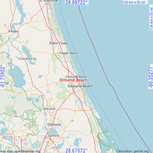
Ormond Beach GPS coordinates[2]
29° 17' 8.916" North, 81° 3' 21.204" West
| Map corner | latitude | longitude |
|---|---|---|
| Upper-left | 29.89722°, | -81.75902° |
| Center: | 29.28581°, | -81.05589° |
| Lower-right: | 28.67072°, | -80.35277° |
| Map W x H: | 136.4×136.4 km | = 84.8×84.8mi |
| max Lat: | 71.29058° ⇑95% North |
| Ormond Beach: | 29.28581° |
| min Lat: | ⇓5% South 19.06759° |
| min Long | Ormond Beach | max Long |
| -171.73463° | -81.05589° | -66.98998° |
| W 69.3%⇐ | ⇒30.7% E |
Elevation
Elevation of Ormond Beach is 6 m = 20 ft, and this is 288.8 m = 948 ft below average elevation for this country.
| Max E: |
3189 m = 10463 ft | 97.4% |
| Avg. | 294.8 m = 967 ft | |
| Ormond Beach | 6 m = 20 ft | |
Min E: |
-60 m = -197 ft | 2.6% |
See also: Ormond Beach elevation on elevation.city.
Geographical zone
Ormond Beach is located in North temperate zone (between Tropic of Cancer and the Arctic Circle). Distance of this Northern Tropic circle is 650.4 km =404.1 mi to South.| Distance of | km | miles | from Ormond Beach |
|---|---|---|---|
| North Pole | 6750.8 | 4194.8 | to North |
| Arctic Circle | 4144.9 | 2575.5 | to North |
| Tropic Cancer | 650.4 | 404.1 | to South |
| Equator | 3256.3 | 2023.4 | to South |


Nearby cities:
15 places around Ormond Beach: (largest is in red/bold)
• Bunnell
28 km =17.4 mi,  315°
315°
• Daytona Beach
8.9 km =5.5 mi,  158°
158°
• Daytona Beach Shores
14.1 km =8.8 mi,  149°
149°
• De Leon Springs
34.2 km =21.3 mi,  237°
237°
• Edgewater
36.2 km =22.5 mi, 155°
• Flagler Beach
22.1 km =13.7 mi,  341°
341°
• Glencoe
30 km =18.6 mi, 164°
• Holly Hill
5 km =3.1 mi, 159°
• New Smyrna Beach
31.5 km =19.6 mi, 156°
• North DeLand
35.3 km =21.9 mi,  221°
221°
• Ormond-by-the-Sea
7.1 km =4.4 mi,  351°
351°
• Ponce Inlet
24 km =14.9 mi, 151°
• Port Orange
17.4 km =10.8 mi, 160°
• Samsula-Spruce Creek
26.3 km =16.3 mi,  181°
181°
• South Daytona
14.2 km =8.8 mi, 159°
Sources, notices
• [Note1] Compared only with cities in United States existing in our database
• [Src1] Map data: © OpenStreetMap contributors (CC-BY-SA)
• [Src2] Other city data from geonames.org with taken over terms of usage.
• [Src3] Geographical zone / Annual Mean Temperature by Robert A. Rohde @ Wikipedia
