Jacksonville geodata
Jacksonville (Florida) is a seat of a second-order administrative division; located in United States in America/New_York (GMT-4) time zone. With population of 868,031 people, there are 15 cities with bigger population in this country. Compared to other cities in United States, 92.4% of cities are located further ↑North; 66.9% of cities are located further ←West and 92.1% of cities have higher elevation than Jacksonville. Note1


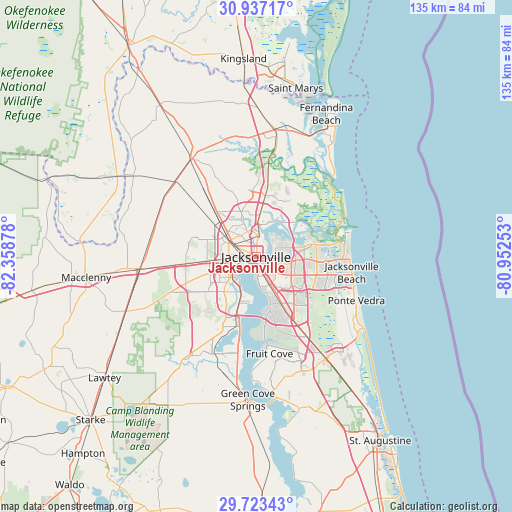
Jacksonville GPS coordinates[2]
30° 19' 55.848" North, 81° 39' 20.34" West
| Map corner | latitude | longitude |
|---|---|---|
| Upper-left | 30.93717°, | -82.35878° |
| Center: | 30.33218°, | -81.65565° |
| Lower-right: | 29.72343°, | -80.95253° |
| Map W x H: | 135×135 km | = 83.9×83.9mi |
| max Lat: | 71.29058° ⇑92.4% North |
| Jacksonville: | 30.33218° |
| min Lat: | ⇓7.6% South 19.06759° |
| min Long | Jacksonville | max Long |
| -171.73463° | -81.65565° | -66.98998° |
| W 66.9%⇐ | ⇒33.1% E |
Elevation
Elevation of Jacksonville is 12 m = 39 ft, and this is 282.8 m = 928 ft below average elevation for this country.
| Max E: |
3189 m = 10463 ft | 92.1% |
| Avg. | 294.8 m = 967 ft | |
| Jacksonville | 12 m = 39 ft | |
Min E: |
-60 m = -197 ft | 7.9% |
See also: Jacksonville elevation on elevation.city.
Geographical zone
Jacksonville is located in North temperate zone (between Tropic of Cancer and the Arctic Circle). Distance of this Northern Tropic circle is 766.7 km =476.4 mi to South.| Distance of | km | miles | from Jacksonville |
|---|---|---|---|
| North Pole | 6634.4 | 4122.4 | to North |
| Arctic Circle | 4028.6 | 2503.3 | to North |
| Tropic Cancer | 766.7 | 476.4 | to South |
| Equator | 3372.6 | 2095.6 | to South |


Nearby cities:
15 places around Jacksonville: (largest is in red/bold)
• Atlantic Beach
24.7 km =15.3 mi,  89°
89°
• Baldwin
30.9 km =19.2 mi,  263°
263°
• Bellair-Meadowbrook Terrace
19 km =11.8 mi,  206°
206°
• Callahan
30.6 km =19 mi,  326°
326°
• Fleming Island
27.2 km =16.9 mi,  192°
192°
• Fruit Cove
24.6 km =15.3 mi,  176°
176°
• Jacksonville Beach
25.5 km =15.8 mi,  99°
99°
• Lakeside
24.9 km =15.5 mi, 205°
• Nassau Village-Ratliff
24.8 km =15.4 mi,  323°
323°
• Neptune Beach
25 km =15.5 mi, 95°
• Oakleaf Plantation
24.9 km =15.5 mi,  223°
223°
• Orange Park
19.1 km =11.9 mi, 194°
• Palm Valley
31 km =19.3 mi,  123°
123°
• Ponte Vedra Beach
27.9 km =17.3 mi,  111°
111°
• St. Johns
29.7 km =18.5 mi,  159°
159°
Sources, notices
• [Note1] Compared only with cities in United States existing in our database
• [Src1] Map data: © OpenStreetMap contributors (CC-BY-SA)
• [Src2] Other city data from geonames.org with taken over terms of usage.
• [Src3] Geographical zone / Annual Mean Temperature by Robert A. Rohde @ Wikipedia
