Nassau Village-Ratliff geodata
Nassau Village-Ratliff (Florida) is a populated place; located in United States in America/New_York (GMT-4) time zone. With population of 5,337 people, there are 6887 cities with bigger population in this country. Compared to other cities in United States, 91.7% of cities are located further ↑North; 66.2% of cities are located further ←West and 96.6% of cities have higher elevation than Nassau Village-Ratliff. Note1


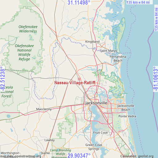
Nassau Village-Ratliff GPS coordinates[2]
30° 30' 39.996" North, 81° 48' 33.3" West
| Map corner | latitude | longitude |
|---|---|---|
| Upper-left | 31.11498°, | -82.51238° |
| Center: | 30.51111°, | -81.80925° |
| Lower-right: | 29.90347°, | -81.10613° |
| Map W x H: | 134.7×134.7 km | = 83.7×83.7mi |
| max Lat: | 71.29058° ⇑91.7% North |
| Nassau Village-Ratliff: | 30.51111° |
| min Lat: | ⇓8.3% South 19.06759° |
| min Long | Nassau Village- | max Long |
| -171.73463° | -81.80925° | -66.98998° |
| W 66.2%⇐ | ⇒33.8% E |
Elevation
Elevation of Nassau Village-Ratliff is 7 m = 23 ft, and this is 287.8 m = 944 ft below average elevation for this country.
| Max E: |
3189 m = 10463 ft | 96.6% |
| Avg. | 294.8 m = 967 ft | |
| Nassau Village-Ratliff | 7 m = 23 ft | |
Min E: |
-60 m = -197 ft | 3.4% |
See also: United States elevation on elevation.city.
Geographical zone
Nassau Village-Ratliff is located in North temperate zone (between Tropic of Cancer and the Arctic Circle). Distance of this Northern Tropic circle is 786.6 km =488.8 mi to South.| Distance of | km | miles | from Nassau Village-Ratliff |
|---|---|---|---|
| North Pole | 6614.5 | 4110.1 | to North |
| Arctic Circle | 4008.7 | 2490.9 | to North |
| Tropic Cancer | 786.6 | 488.8 | to South |
| Equator | 3392.5 | 2108 | to South |


Nearby cities:
15 places around Nassau Village-Ratliff: (largest is in red/bold)
• Baldwin
28.1 km =17.5 mi,  214°
214°
• Bellair-Meadowbrook Terrace
37.5 km =23.3 mi,  170°
170°
• Callahan
6 km =3.7 mi,  340°
340°
• Fernandina Beach
37.6 km =23.4 mi,  62°
62°
• Folkston
40.5 km =25.2 mi,  331°
331°
• Hilliard
22.5 km =14 mi, 332°
• Jacksonville
24.8 km =15.4 mi,  143°
143°
• Kings Bay Base
39.5 km =24.5 mi,  36°
36°
• Kingsland
34.1 km =21.2 mi,  19°
19°
• Macclenny
39.3 km =24.4 mi,  229°
229°
• Oakleaf Plantation
37.9 km =23.5 mi,  183°
183°
• Orange Park
39.6 km =24.6 mi, 165°
• St Marys
35.5 km =22.1 mi, 39°
• St. Marys
35 km =21.7 mi,  45°
45°
• Yulee
23.6 km =14.7 mi, 55°
Sources, notices
• [Note1] Compared only with cities in United States existing in our database
• [Src1] Map data: © OpenStreetMap contributors (CC-BY-SA)
• [Src2] Other city data from geonames.org with taken over terms of usage.
• [Src3] Geographical zone / Annual Mean Temperature by Robert A. Rohde @ Wikipedia
