Sun City Center geodata
Sun City Center (Florida) is a populated place; located in United States in America/New_York (GMT-4) time zone. With population of 19,258 people, there are 2609 cities with bigger population in this country. Compared to other cities in United States, 97.1% of cities are located further ↑North; 64.5% of cities are located further ←West and 88.6% of cities have higher elevation than Sun City Center. Note1


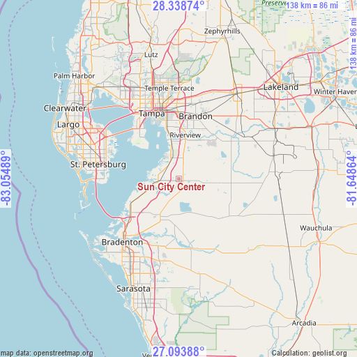
Sun City Center GPS coordinates[2]
27° 43' 5.124" North, 82° 21' 6.336" West
| Map corner | latitude | longitude |
|---|---|---|
| Upper-left | 28.33874°, | -83.05489° |
| Center: | 27.71809°, | -82.35176° |
| Lower-right: | 27.09388°, | -81.64864° |
| Map W x H: | 138.4×138.4 km | = 86×86mi |
| max Lat: | 71.29058° ⇑97.1% North |
| Sun City Center: | 27.71809° |
| min Lat: | ⇓2.9% South 19.06759° |
| min Long | Sun City Center | max Long |
| -171.73463° | -82.35176° | -66.98998° |
| W 64.5%⇐ | ⇒35.5% E |
Elevation
Elevation of Sun City Center is 19 m = 62 ft, and this is 275.8 m = 905 ft below average elevation for this country.
| Max E: |
3189 m = 10463 ft | 88.6% |
| Avg. | 294.8 m = 967 ft | |
| Sun City Center | 19 m = 62 ft | |
Min E: |
-60 m = -197 ft | 11.4% |
See also: United States elevation on elevation.city.
Geographical zone
Sun City Center is located in North temperate zone (between Tropic of Cancer and the Arctic Circle). Distance of this Northern Tropic circle is 476 km =295.8 mi to South.| Distance of | km | miles | from Sun City Center |
|---|---|---|---|
| North Pole | 6925.1 | 4303.1 | to North |
| Arctic Circle | 4319.2 | 2683.8 | to North |
| Tropic Cancer | 476 | 295.8 | to South |
| Equator | 3082 | 1915.1 | to South |


Nearby cities:
15 places around Sun City Center: (largest is in red/bold)
• Apollo Beach
8.2 km =5.1 mi,  318°
318°
• Balm
10 km =6.2 mi,  62°
62°
• Bloomingdale
22.4 km =13.9 mi,  29°
29°
• Boyette
16.8 km =10.4 mi,  48°
48°
• Brandon
25.3 km =15.7 mi,  14°
14°
• Ellenton
27.9 km =17.3 mi,  218°
218°
• Fish Hawk
20.2 km =12.6 mi,  43°
43°
• Gibsonton
15.4 km =9.6 mi,  348°
348°
• Palm River-Clair Mel
23 km =14.3 mi, 353°
• Progress Village
20.3 km =12.6 mi,  356°
356°
• Riverview
16.6 km =10.3 mi, 8°
• Ruskin
8 km =5 mi,  272°
272°
• Tampa
27.6 km =17.1 mi,  337°
337°
• Valrico
26.9 km =16.7 mi,  24°
24°
• Wimauma
5.2 km =3.2 mi,  96°
96°
Sources, notices
• [Note1] Compared only with cities in United States existing in our database
• [Src1] Map data: © OpenStreetMap contributors (CC-BY-SA)
• [Src2] Other city data from geonames.org with taken over terms of usage.
• [Src3] Geographical zone / Annual Mean Temperature by Robert A. Rohde @ Wikipedia
