Cumming geodata
Cumming (Georgia) is a seat of a second-order administrative division; located in United States in America/New_York (GMT-4) time zone. With population of 5,718 people, there are 6599 cities with bigger population in this country. Compared to other cities in United States, 78.9% of cities are located further ↑North; 58.9% of cities are located further ←West and 81.6% of cities have lower elevation than Cumming. Note1


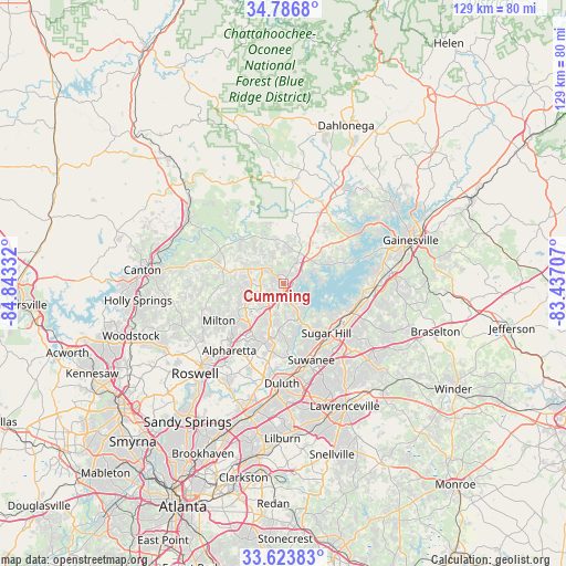
Cumming GPS coordinates[2]
34° 12' 26.352" North, 84° 8' 24.684" West
| Map corner | latitude | longitude |
|---|---|---|
| Upper-left | 34.7868°, | -84.84332° |
| Center: | 34.20732°, | -84.14019° |
| Lower-right: | 33.62383°, | -83.43707° |
| Map W x H: | 129.3×129.3 km | = 80.3×80.3mi |
| max Lat: | 71.29058° ⇑78.9% North |
| Cumming: | 34.20732° |
| min Lat: | ⇓21.1% South 19.06759° |
| min Long | Cumming | max Long |
| -171.73463° | -84.14019° | -66.98998° |
| W 58.9%⇐ | ⇒41.1% E |
Elevation
Elevation of Cumming is 372 m = 1220 ft, and this is 77.2 m = 253 ft above average elevation for this country.
| Max E: |
3189 m = 10463 ft | 18.4% |
| Cumming | 372 m 1220 ft | |
| Avg. | 294.8 m = 967 ft | |
Min E: |
-60 m = -197 ft | 81.6% |
See also: United States elevation on elevation.city.
Geographical zone
Cumming is located in North temperate zone (between Tropic of Cancer and the Arctic Circle). Distance of this Northern Tropic circle is 1197.6 km =744.2 mi to South.| Distance of | km | miles | from Cumming |
|---|---|---|---|
| North Pole | 6203.6 | 3854.7 | to North |
| Arctic Circle | 3597.7 | 2235.5 | to North |
| Tropic Cancer | 1197.6 | 744.2 | to South |
| Equator | 3803.5 | 2363.4 | to South |


Nearby cities:
15 places around Cumming: (largest is in red/bold)
• Alpharetta
20.4 km =12.7 mi,  223°
223°
• Ball Ground
26.1 km =16.2 mi,  303°
303°
• Berkeley Lake
25.2 km =15.7 mi,  189°
189°
• Buford
15.8 km =9.8 mi,  127°
127°
• Dawsonville
23.9 km =14.9 mi,  4°
4°
• Duluth
22.7 km =14.1 mi,  181°
181°
• Flowery Branch
19.9 km =12.4 mi,  97°
97°
• Johns Creek
20.6 km =12.8 mi,  195°
195°
• Milton
17 km =10.6 mi,  240°
240°
• Mountain Park
28.6 km =17.8 mi, 240°
• Nelson
28.8 km =17.9 mi,  312°
312°
• Oakwood
23.6 km =14.7 mi,  84°
84°
• Peachtree Corners
27.4 km =17 mi, 195°
• Sugar Hill
14.9 km =9.3 mi,  138°
138°
• Suwanee
18.5 km =11.5 mi,  159°
159°
Sources, notices
• [Note1] Compared only with cities in United States existing in our database
• [Src1] Map data: © OpenStreetMap contributors (CC-BY-SA)
• [Src2] Other city data from geonames.org with taken over terms of usage.
• [Src3] Geographical zone / Annual Mean Temperature by Robert A. Rohde @ Wikipedia
