Augusta geodata
Augusta (Georgia) is a seat of a second-order administrative division; located in United States in America/New_York (GMT-4) time zone. With population of 43,459 people, there are 1098 cities with bigger population in this country. Compared to other cities in United States, 83.2% of cities are located further ↑North; 65.6% of cities are located further ←West and 80.6% of cities have higher elevation than Augusta. Note1


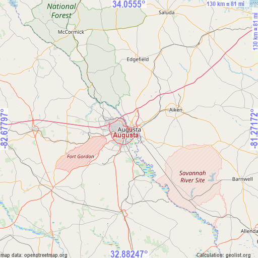
Augusta GPS coordinates[2]
33° 28' 15.492" North, 81° 58' 29.424" West
| Map corner | latitude | longitude |
|---|---|---|
| Upper-left | 34.0555°, | -82.67797° |
| Center: | 33.47097°, | -81.97484° |
| Lower-right: | 32.88247°, | -81.27172° |
| Map W x H: | 130.4×130.4 km | = 81×81mi |
| max Lat: | 71.29058° ⇑83.2% North |
| Augusta: | 33.47097° |
| min Lat: | ⇓16.8% South 19.06759° |
| min Long | Augusta | max Long |
| -171.73463° | -81.97484° | -66.98998° |
| W 65.6%⇐ | ⇒34.4% E |
Elevation
Elevation of Augusta is 44 m = 144 ft, and this is 250.8 m = 823 ft below average elevation for this country.
| Max E: |
3189 m = 10463 ft | 80.6% |
| Avg. | 294.8 m = 967 ft | |
| Augusta | 44 m = 144 ft | |
Min E: |
-60 m = -197 ft | 19.4% |
See also: Augusta elevation on elevation.city.
Geographical zone
Augusta is located in North temperate zone (between Tropic of Cancer and the Arctic Circle). Distance of this Northern Tropic circle is 1115.7 km =693.3 mi to South.| Distance of | km | miles | from Augusta |
|---|---|---|---|
| North Pole | 6285.4 | 3905.6 | to North |
| Arctic Circle | 3679.6 | 2286.4 | to North |
| Tropic Cancer | 1115.7 | 693.3 | to South |
| Equator | 3721.6 | 2312.5 | to South |


Nearby cities:
15 places around Augusta: (largest is in red/bold)
• Belvedere
7.2 km =4.5 mi,  22°
22°
• Burnettown
12.7 km =7.9 mi,  67°
67°
• Clearwater
8.2 km =5.1 mi, 69°
• Evans
16 km =9.9 mi,  295°
295°
• Gloverville
14.7 km =9.1 mi, 65°
• Graniteville
18.6 km =11.6 mi,  56°
56°
• Grovetown
20.8 km =12.9 mi,  263°
263°
• Hephzibah
20.8 km =12.9 mi,  212°
212°
• Jackson
23.7 km =14.7 mi,  133°
133°
• Kingston
9.7 km =6 mi,  276°
276°
• Langley
13.2 km =8.2 mi, 66°
• Martinez
10.7 km =6.6 mi, 298°
• Murphys Estates
14.8 km =9.2 mi,  11°
11°
• North Augusta
3.5 km =2.2 mi, 14°
• Warrenville
18.2 km =11.3 mi, 60°
Sources, notices
• [Note1] Compared only with cities in United States existing in our database
• [Src1] Map data: © OpenStreetMap contributors (CC-BY-SA)
• [Src2] Other city data from geonames.org with taken over terms of usage.
• [Src3] Geographical zone / Annual Mean Temperature by Robert A. Rohde @ Wikipedia
