North Augusta geodata
North Augusta (South Carolina) is a populated place; located in United States in America/New_York (GMT-4) time zone. With population of 22,522 people, there are 2251 cities with bigger population in this country. Compared to other cities in United States, 83.1% of cities are located further ↑North; 65.7% of cities are located further ←West and 66.2% of cities have higher elevation than North Augusta. Note1


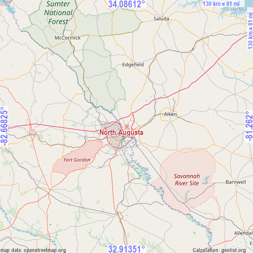
North Augusta GPS coordinates[2]
33° 30' 6.48" North, 81° 57' 54.432" West
| Map corner | latitude | longitude |
|---|---|---|
| Upper-left | 34.08612°, | -82.66825° |
| Center: | 33.5018°, | -81.96512° |
| Lower-right: | 32.91351°, | -81.262° |
| Map W x H: | 130.4×130.4 km | = 81×81mi |
| max Lat: | 71.29058° ⇑83.1% North |
| North Augusta: | 33.5018° |
| min Lat: | ⇓16.9% South 19.06759° |
| min Long | North Augusta | max Long |
| -171.73463° | -81.96512° | -66.98998° |
| W 65.7%⇐ | ⇒34.3% E |
Elevation
Elevation of North Augusta is 122 m = 400 ft, and this is 172.8 m = 567 ft below average elevation for this country.
| Max E: |
3189 m = 10463 ft | 66.2% |
| Avg. | 294.8 m = 967 ft | |
| North Augusta | 122 m = 400 ft | |
Min E: |
-60 m = -197 ft | 33.8% |
See also: United States elevation on elevation.city.
Geographical zone
North Augusta is located in North temperate zone (between Tropic of Cancer and the Arctic Circle). Distance of this Northern Tropic circle is 1119.1 km =695.4 mi to South.| Distance of | km | miles | from North Augusta |
|---|---|---|---|
| North Pole | 6282 | 3903.5 | to North |
| Arctic Circle | 3676.1 | 2284.2 | to North |
| Tropic Cancer | 1119.1 | 695.4 | to South |
| Equator | 3725.1 | 2314.7 | to South |


Nearby cities:
15 places around North Augusta: (largest is in red/bold)
• Aiken
23.7 km =14.7 mi,  74°
74°
• Augusta
3.5 km =2.2 mi,  194°
194°
• Belvedere
3.7 km =2.3 mi,  30°
30°
• Burnettown
10.9 km =6.8 mi,  81°
81°
• Clearwater
6.8 km =4.2 mi,  94°
94°
• Evans
15.8 km =9.8 mi,  283°
283°
• Gloverville
12.8 km =8 mi, 77°
• Graniteville
16.1 km =10 mi,  64°
64°
• Grovetown
22.4 km =13.9 mi,  255°
255°
• Hephzibah
24.2 km =15 mi,  210°
210°
• Kingston
10.8 km =6.7 mi, 257°
• Langley
11.4 km =7.1 mi, 80°
• Martinez
10.4 km =6.5 mi, 279°
• Murphys Estates
11.2 km =7 mi,  9°
9°
• Warrenville
15.9 km =9.9 mi, 69°
Sources, notices
• [Note1] Compared only with cities in United States existing in our database
• [Src1] Map data: © OpenStreetMap contributors (CC-BY-SA)
• [Src2] Other city data from geonames.org with taken over terms of usage.
• [Src3] Geographical zone / Annual Mean Temperature by Robert A. Rohde @ Wikipedia
