Brookhaven geodata
Brookhaven (Georgia) is a populated place; located in United States in America/New_York (GMT-4) time zone. With population of 51,910 people, there are 908 cities with bigger population in this country. Compared to other cities in United States, 81.2% of cities are located further ↑North; 58.1% of cities are located further ←West and 72.4% of cities have lower elevation than Brookhaven. Note1


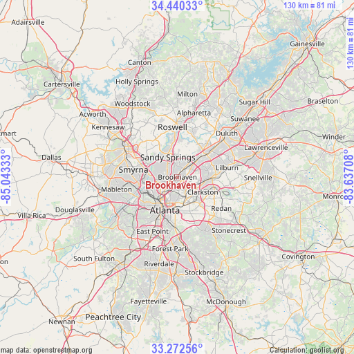
Brookhaven GPS coordinates[2]
33° 51' 30.384" North, 84° 20' 24.72" West
| Map corner | latitude | longitude |
|---|---|---|
| Upper-left | 34.44033°, | -85.04333° |
| Center: | 33.85844°, | -84.3402° |
| Lower-right: | 33.27256°, | -83.63708° |
| Map W x H: | 129.8×129.8 km | = 80.7×80.7mi |
| max Lat: | 71.29058° ⇑81.2% North |
| Brookhaven: | 33.85844° |
| min Lat: | ⇓18.8% South 19.06759° |
| min Long | Brookhaven | max Long |
| -171.73463° | -84.3402° | -66.98998° |
| W 58.1%⇐ | ⇒41.9% E |
Elevation
Elevation of Brookhaven is 298 m = 978 ft, and this is 3.2 m = 10 ft above average elevation for this country.
| Max E: |
3189 m = 10463 ft | 27.6% |
| Brookhaven | 298 m 978 ft | |
| Avg. | 294.8 m = 967 ft | |
Min E: |
-60 m = -197 ft | 72.4% |
See also: Brookhaven elevation on elevation.city.
Geographical zone
Brookhaven is located in North temperate zone (between Tropic of Cancer and the Arctic Circle). Distance of this Northern Tropic circle is 1158.8 km =720 mi to South.| Distance of | km | miles | from Brookhaven |
|---|---|---|---|
| North Pole | 6242.4 | 3878.8 | to North |
| Arctic Circle | 3636.5 | 2259.6 | to North |
| Tropic Cancer | 1158.8 | 720 | to South |
| Equator | 3764.7 | 2339.3 | to South |


Nearby cities:
15 places around Brookhaven: (largest is in red/bold)
• Atlanta
12.9 km =8 mi,  199°
199°
• Avondale Estates
11.8 km =7.3 mi,  145°
145°
• Chamblee
5.3 km =3.3 mi,  45°
45°
• Clarkston
10.8 km =6.7 mi,  120°
120°
• Decatur
10.1 km =6.3 mi,  156°
156°
• Doraville
6.9 km =4.3 mi, 49°
• Druid Hills
8.7 km =5.4 mi,  177°
177°
• Dunwoody
9.8 km =6.1 mi,  3°
3°
• North Atlanta
0.8 km =0.5 mi,  24°
24°
• North Decatur
8.2 km =5.1 mi, 157°
• North Druid Hills
5.3 km =3.3 mi, 151°
• Sandy Springs
8.1 km =5 mi,  334°
334°
• Scottdale
10.4 km =6.5 mi,  137°
137°
• Tucker
11.4 km =7.1 mi,  92°
92°
• Vinings
11.5 km =7.1 mi,  273°
273°
Sources, notices
• [Note1] Compared only with cities in United States existing in our database
• [Src1] Map data: © OpenStreetMap contributors (CC-BY-SA)
• [Src2] Other city data from geonames.org with taken over terms of usage.
• [Src3] Geographical zone / Annual Mean Temperature by Robert A. Rohde @ Wikipedia
