Atlanta geodata
Atlanta (Georgia) is a seat of a first-order administrative division; located in United States in America/New_York (GMT-4) time zone. With population of 463,878 people, there are 44 cities with bigger population in this country. Compared to other cities in United States, 81.8% of cities are located further ↑North; 57.8% of cities are located further ←West and 78% of cities have lower elevation than Atlanta. Note1


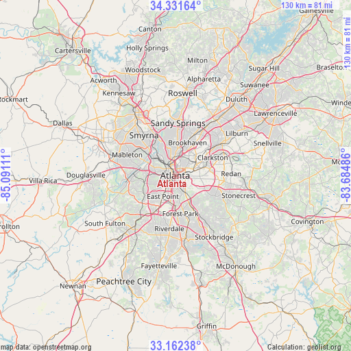
Atlanta GPS coordinates[2]
33° 44' 56.4" North, 84° 23' 16.728" West
| Map corner | latitude | longitude |
|---|---|---|
| Upper-left | 34.33164°, | -85.09111° |
| Center: | 33.749°, | -84.38798° |
| Lower-right: | 33.16238°, | -83.68486° |
| Map W x H: | 130×130 km | = 80.8×80.8mi |
| max Lat: | 71.29058° ⇑81.8% North |
| Atlanta: | 33.749° |
| min Lat: | ⇓18.2% South 19.06759° |
| min Long | Atlanta | max Long |
| -171.73463° | -84.38798° | -66.98998° |
| W 57.8%⇐ | ⇒42.2% E |
Elevation
Elevation of Atlanta is 336 m = 1102 ft, and this is 41.2 m = 135 ft above average elevation for this country.
| Max E: |
3189 m = 10463 ft | 22% |
| Atlanta | 336 m 1102 ft | |
| Avg. | 294.8 m = 967 ft | |
Min E: |
-60 m = -197 ft | 78% |
See also: Atlanta elevation on elevation.city.
Geographical zone
Atlanta is located in North temperate zone (between Tropic of Cancer and the Arctic Circle). Distance of this Northern Tropic circle is 1146.6 km =712.5 mi to South.| Distance of | km | miles | from Atlanta |
|---|---|---|---|
| North Pole | 6254.5 | 3886.4 | to North |
| Arctic Circle | 3648.6 | 2267.1 | to North |
| Tropic Cancer | 1146.6 | 712.5 | to South |
| Equator | 3752.5 | 2331.7 | to South |


Nearby cities:
15 places around Atlanta: (largest is in red/bold)
• Avondale Estates
11.4 km =7.1 mi,  77°
77°
• Belvedere Park
11.2 km =7 mi,  86°
86°
• Brookhaven
12.9 km =8 mi,  19°
19°
• Candler-McAfee
11 km =6.8 mi,  103°
103°
• College Park
12 km =7.5 mi,  208°
208°
• Conley
12.9 km =8 mi,  153°
153°
• Decatur
8.9 km =5.5 mi,  71°
71°
• Druid Hills
5.9 km =3.7 mi,  53°
53°
• East Point
9.1 km =5.7 mi, 211°
• Gresham Park
8.5 km =5.3 mi,  126°
126°
• Hapeville
10.1 km =6.3 mi,  191°
191°
• North Decatur
8.9 km =5.5 mi,  58°
58°
• North Druid Hills
10.2 km =6.3 mi,  42°
42°
• Panthersville
11.7 km =7.3 mi,  113°
113°
• Scottdale
12.3 km =7.6 mi, 68°
Sources, notices
• [Note1] Compared only with cities in United States existing in our database
• [Src1] Map data: © OpenStreetMap contributors (CC-BY-SA)
• [Src2] Other city data from geonames.org with taken over terms of usage.
• [Src3] Geographical zone / Annual Mean Temperature by Robert A. Rohde @ Wikipedia
