Vinings geodata
Vinings (Georgia) is a populated place; located in United States in America/New_York (GMT-4) time zone. With population of 9,734 people, there are 4552 cities with bigger population in this country. Compared to other cities in United States, 81.2% of cities are located further ↑North; 57.5% of cities are located further ←West and 69.5% of cities have lower elevation than Vinings. Note1


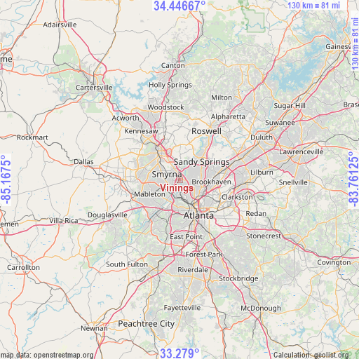
Vinings GPS coordinates[2]
33° 51' 53.388" North, 84° 27' 51.732" West
| Map corner | latitude | longitude |
|---|---|---|
| Upper-left | 34.44667°, | -85.1675° |
| Center: | 33.86483°, | -84.46437° |
| Lower-right: | 33.279°, | -83.76125° |
| Map W x H: | 129.8×129.8 km | = 80.7×80.7mi |
| max Lat: | 71.29058° ⇑81.2% North |
| Vinings: | 33.86483° |
| min Lat: | ⇓18.8% South 19.06759° |
| min Long | Vinings | max Long |
| -171.73463° | -84.46437° | -66.98998° |
| W 57.5%⇐ | ⇒42.5% E |
Elevation
Elevation of Vinings is 283 m = 928 ft, and this is 11.8 m = 39 ft below average elevation for this country.
| Max E: |
3189 m = 10463 ft | 30.5% |
| Avg. | 294.8 m = 967 ft | |
| Vinings | 283 m = 928 ft | |
Min E: |
-60 m = -197 ft | 69.5% |
See also: United States elevation on elevation.city.
Geographical zone
Vinings is located in North temperate zone (between Tropic of Cancer and the Arctic Circle). Distance of this Northern Tropic circle is 1159.5 km =720.5 mi to South.| Distance of | km | miles | from Vinings |
|---|---|---|---|
| North Pole | 6241.6 | 3878.3 | to North |
| Arctic Circle | 3635.8 | 2259.2 | to North |
| Tropic Cancer | 1159.5 | 720.5 | to South |
| Equator | 3765.4 | 2339.7 | to South |


Nearby cities:
15 places around Vinings: (largest is in red/bold)
• Atlanta
14.7 km =9.1 mi,  151°
151°
• Austell
16.7 km =10.4 mi,  249°
249°
• Brookhaven
11.5 km =7.1 mi,  93°
93°
• Chamblee
15.6 km =9.7 mi,  78°
78°
• Doraville
17.1 km =10.6 mi, 77°
• Druid Hills
15.1 km =9.4 mi,  128°
128°
• Dunwoody
15 km =9.3 mi,  52°
52°
• Fair Oaks
9.4 km =5.8 mi,  307°
307°
• Mableton
12 km =7.5 mi,  244°
244°
• Marietta
12.6 km =7.8 mi,  321°
321°
• North Atlanta
11.8 km =7.3 mi, 89°
• North Decatur
16.8 km =10.4 mi,  119°
119°
• North Druid Hills
14.9 km =9.3 mi,  110°
110°
• Sandy Springs
10.3 km =6.4 mi, 50°
• Smyrna
5.1 km =3.2 mi,  294°
294°
Sources, notices
• [Note1] Compared only with cities in United States existing in our database
• [Src1] Map data: © OpenStreetMap contributors (CC-BY-SA)
• [Src2] Other city data from geonames.org with taken over terms of usage.
• [Src3] Geographical zone / Annual Mean Temperature by Robert A. Rohde @ Wikipedia
