Cedartown geodata
Cedartown (Georgia) is a seat of a second-order administrative division; located in United States in America/New_York (GMT-4) time zone. With population of 9,750 people, there are 4549 cities with bigger population in this country. Compared to other cities in United States, 80.2% of cities are located further ↑North; 55.2% of cities are located further ←West and 60.7% of cities have lower elevation than Cedartown. Note1


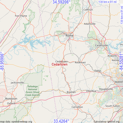
Cedartown GPS coordinates[2]
34° 0' 40.428" North, 85° 15' 21.348" West
| Map corner | latitude | longitude |
|---|---|---|
| Upper-left | 34.59206°, | -85.95906° |
| Center: | 34.01123°, | -85.25593° |
| Lower-right: | 33.4264°, | -84.55281° |
| Map W x H: | 129.6×129.6 km | = 80.5×80.5mi |
| max Lat: | 71.29058° ⇑80.2% North |
| Cedartown: | 34.01123° |
| min Lat: | ⇓19.8% South 19.06759° |
| min Long | Cedartown | max Long |
| -171.73463° | -85.25593° | -66.98998° |
| W 55.2%⇐ | ⇒44.8% E |
Elevation
Elevation of Cedartown is 243 m = 797 ft, and this is 51.8 m = 170 ft below average elevation for this country.
| Max E: |
3189 m = 10463 ft | 39.3% |
| Avg. | 294.8 m = 967 ft | |
| Cedartown | 243 m = 797 ft | |
Min E: |
-60 m = -197 ft | 60.7% |
See also: United States elevation on elevation.city.
Geographical zone
Cedartown is located in North temperate zone (between Tropic of Cancer and the Arctic Circle). Distance of this Northern Tropic circle is 1175.8 km =730.6 mi to South.| Distance of | km | miles | from Cedartown |
|---|---|---|---|
| North Pole | 6225.4 | 3868.3 | to North |
| Arctic Circle | 3619.5 | 2249.1 | to North |
| Tropic Cancer | 1175.8 | 730.6 | to South |
| Equator | 3781.7 | 2349.8 | to South |


Nearby cities:
15 places around Cedartown: (largest is in red/bold)
• Aragon
18.8 km =11.7 mi,  78°
78°
• Bremen
33.8 km =21 mi,  162°
162°
• Buchanan
24 km =14.9 mi, 164°
• Cave Spring
13 km =8.1 mi,  325°
325°
• Cedar Bluff
39.9 km =24.8 mi,  305°
305°
• Dallas
39.5 km =24.5 mi,  104°
104°
• Euharlee
33.2 km =20.6 mi,  63°
63°
• Kingston
38.1 km =23.7 mi,  48°
48°
• Lindale
20.9 km =13 mi,  20°
20°
• Piedmont
34.2 km =21.3 mi,  253°
253°
• Rockmart
19.8 km =12.3 mi,  92°
92°
• Rome
28.6 km =17.8 mi, 17°
• Tallapoosa
29.8 km =18.5 mi,  185°
185°
• Temple
36.8 km =22.9 mi,  145°
145°
• Waco
34.9 km =21.7 mi,  168°
168°
Sources, notices
• [Note1] Compared only with cities in United States existing in our database
• [Src1] Map data: © OpenStreetMap contributors (CC-BY-SA)
• [Src2] Other city data from geonames.org with taken over terms of usage.
• [Src3] Geographical zone / Annual Mean Temperature by Robert A. Rohde @ Wikipedia
