Temple geodata
Temple (Georgia) is a populated place; located in United States in America/New_York (GMT-4) time zone. With population of 4,313 people, there are 7852 cities with bigger population in this country. Compared to other cities in United States, 81.9% of cities are located further ↑North; 55.8% of cities are located further ←West and 80.1% of cities have lower elevation than Temple. Note1


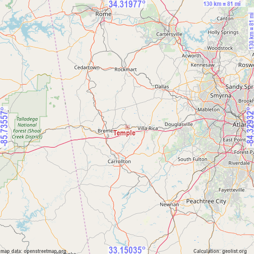
Temple GPS coordinates[2]
33° 44' 13.38" North, 85° 1' 56.784" West
| Map corner | latitude | longitude |
|---|---|---|
| Upper-left | 34.31977°, | -85.73557° |
| Center: | 33.73705°, | -85.03244° |
| Lower-right: | 33.15035°, | -84.32932° |
| Map W x H: | 130×130 km | = 80.8×80.8mi |
| max Lat: | 71.29058° ⇑81.9% North |
| Temple: | 33.73705° |
| min Lat: | ⇓18.1% South 19.06759° |
| min Long | Temple | max Long |
| -171.73463° | -85.03244° | -66.98998° |
| W 55.8%⇐ | ⇒44.2% E |
Elevation
Elevation of Temple is 355 m = 1165 ft, and this is 60.2 m = 198 ft above average elevation for this country.
| Max E: |
3189 m = 10463 ft | 19.9% |
| Temple | 355 m 1165 ft | |
| Avg. | 294.8 m = 967 ft | |
Min E: |
-60 m = -197 ft | 80.1% |
See also: United States elevation on elevation.city.
Geographical zone
Temple is located in North temperate zone (between Tropic of Cancer and the Arctic Circle). Distance of this Northern Tropic circle is 1145.3 km =711.7 mi to South.| Distance of | km | miles | from Temple |
|---|---|---|---|
| North Pole | 6255.9 | 3887.2 | to North |
| Arctic Circle | 3650 | 2268 | to North |
| Tropic Cancer | 1145.3 | 711.7 | to South |
| Equator | 3751.2 | 2330.9 | to South |


Nearby cities:
15 places around Temple: (largest is in red/bold)
• Aragon
34.4 km =21.4 mi,  356°
356°
• Bowdon
30.1 km =18.7 mi,  222°
222°
• Bremen
10.6 km =6.6 mi,  260°
260°
• Buchanan
16.2 km =10.1 mi,  296°
296°
• Carrollton
17.9 km =11.1 mi,  193°
193°
• Chattahoochee Hills
32.6 km =20.3 mi,  129°
129°
• Dallas
27.3 km =17 mi,  40°
40°
• Douglasville
26.4 km =16.4 mi,  86°
86°
• Hiram
29.3 km =18.2 mi,  58°
58°
• Mount Zion
18.3 km =11.4 mi,  231°
231°
• Rockmart
29.5 km =18.3 mi, 358°
• Tallapoosa
23.6 km =14.7 mi,  272°
272°
• Villa Rica
10.5 km =6.5 mi, 93°
• Waco
14.5 km =9 mi,  254°
254°
• Whitesburg
29.2 km =18.1 mi,  157°
157°
Sources, notices
• [Note1] Compared only with cities in United States existing in our database
• [Src1] Map data: © OpenStreetMap contributors (CC-BY-SA)
• [Src2] Other city data from geonames.org with taken over terms of usage.
• [Src3] Geographical zone / Annual Mean Temperature by Robert A. Rohde @ Wikipedia
