Dawsonville geodata
Dawsonville (Georgia) is a seat of a second-order administrative division; located in United States in America/New_York (GMT-4) time zone. With population of 2,525 people, there are 10554 cities with bigger population in this country. Compared to other cities in United States, 78% of cities are located further ↑North; 59% of cities are located further ←West and 84.7% of cities have lower elevation than Dawsonville. Note1


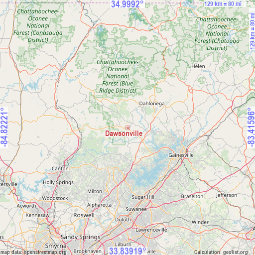
Dawsonville GPS coordinates[2]
34° 25' 16.356" North, 84° 7' 8.688" West
| Map corner | latitude | longitude |
|---|---|---|
| Upper-left | 34.9992°, | -84.82221° |
| Center: | 34.42121°, | -84.11908° |
| Lower-right: | 33.83919°, | -83.41596° |
| Map W x H: | 129×129 km | = 80.2×80.2mi |
| max Lat: | 71.29058° ⇑78% North |
| Dawsonville: | 34.42121° |
| min Lat: | ⇓22% South 19.06759° |
| min Long | Dawsonville | max Long |
| -171.73463° | -84.11908° | -66.98998° |
| W 59%⇐ | ⇒41% E |
Elevation
Elevation of Dawsonville is 417 m = 1368 ft, and this is 122.2 m = 401 ft above average elevation for this country.
| Max E: |
3189 m = 10463 ft | 15.3% |
| Dawsonville | 417 m 1368 ft | |
| Avg. | 294.8 m = 967 ft | |
Min E: |
-60 m = -197 ft | 84.7% |
See also: United States elevation on elevation.city.
Geographical zone
Dawsonville is located in North temperate zone (between Tropic of Cancer and the Arctic Circle). Distance of this Northern Tropic circle is 1221.4 km =758.9 mi to South.| Distance of | km | miles | from Dawsonville |
|---|---|---|---|
| North Pole | 6179.8 | 3839.9 | to North |
| Arctic Circle | 3573.9 | 2220.7 | to North |
| Tropic Cancer | 1221.4 | 758.9 | to South |
| Equator | 3827.3 | 2378.2 | to South |


Nearby cities:
15 places around Dawsonville: (largest is in red/bold)
• Ball Ground
25.4 km =15.8 mi,  248°
248°
• Buford
35 km =21.7 mi,  162°
162°
• Canton
39.8 km =24.7 mi,  238°
238°
• Clermont
32.3 km =20.1 mi,  78°
78°
• Cleveland
38 km =23.6 mi,  59°
59°
• Cumming
23.9 km =14.9 mi,  184°
184°
• Dahlonega
17.5 km =10.9 mi,  44°
44°
• Flowery Branch
31.7 km =19.7 mi,  145°
145°
• Gainesville
30.4 km =18.9 mi,  116°
116°
• Jasper
28.9 km =18 mi,  280°
280°
• Milton
36.2 km =22.5 mi,  207°
207°
• Nelson
23.5 km =14.6 mi,  259°
259°
• Oakwood
30.5 km =19 mi,  134°
134°
• Sugar Hill
35.9 km =22.3 mi,  167°
167°
• Suwanee
41.3 km =25.7 mi, 173°
Sources, notices
• [Note1] Compared only with cities in United States existing in our database
• [Src1] Map data: © OpenStreetMap contributors (CC-BY-SA)
• [Src2] Other city data from geonames.org with taken over terms of usage.
• [Src3] Geographical zone / Annual Mean Temperature by Robert A. Rohde @ Wikipedia
