East Point geodata
East Point (Georgia) is a populated place; located in United States in America/New_York (GMT-4) time zone. With population of 35,467 people, there are 1389 cities with bigger population in this country. Compared to other cities in United States, 82.2% of cities are located further ↑North; 57.7% of cities are located further ←West and 76.4% of cities have lower elevation than East Point. Note1


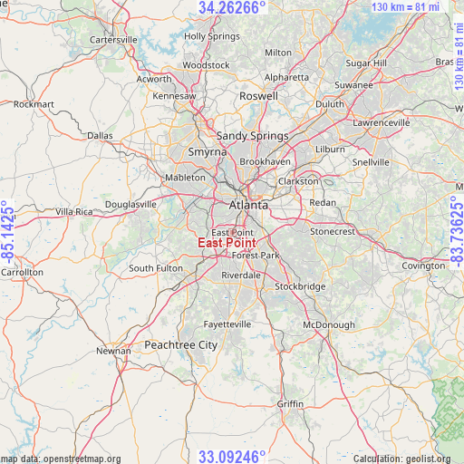
East Point GPS coordinates[2]
33° 40' 46.38" North, 84° 26' 21.732" West
| Map corner | latitude | longitude |
|---|---|---|
| Upper-left | 34.26266°, | -85.1425° |
| Center: | 33.67955°, | -84.43937° |
| Lower-right: | 33.09246°, | -83.73625° |
| Map W x H: | 130.1×130.1 km | = 80.8×80.8mi |
| max Lat: | 71.29058° ⇑82.2% North |
| East Point: | 33.67955° |
| min Lat: | ⇓17.8% South 19.06759° |
| min Long | East Point | max Long |
| -171.73463° | -84.43937° | -66.98998° |
| W 57.7%⇐ | ⇒42.3% E |
Elevation
Elevation of East Point is 323 m = 1060 ft, and this is 28.2 m = 93 ft above average elevation for this country.
| Max E: |
3189 m = 10463 ft | 23.6% |
| East Point | 323 m 1060 ft | |
| Avg. | 294.8 m = 967 ft | |
Min E: |
-60 m = -197 ft | 76.4% |
See also: United States elevation on elevation.city.
Geographical zone
East Point is located in North temperate zone (between Tropic of Cancer and the Arctic Circle). Distance of this Northern Tropic circle is 1138.9 km =707.7 mi to South.| Distance of | km | miles | from East Point |
|---|---|---|---|
| North Pole | 6262.2 | 3891.1 | to North |
| Arctic Circle | 3656.4 | 2272 | to North |
| Tropic Cancer | 1138.9 | 707.7 | to South |
| Equator | 3744.8 | 2326.9 | to South |


Nearby cities:
15 places around East Point: (largest is in red/bold)
• Atlanta
9.1 km =5.7 mi,  31°
31°
• Candler-McAfee
16.3 km =10.1 mi,  71°
71°
• College Park
3 km =1.9 mi,  197°
197°
• Conley
11.2 km =7 mi,  110°
110°
• Decatur
16.9 km =10.5 mi,  51°
51°
• Druid Hills
14.7 km =9.1 mi,  40°
40°
• Forest Park
9.1 km =5.7 mi,  134°
134°
• Gresham Park
11.9 km =7.4 mi,  77°
77°
• Hapeville
3.5 km =2.2 mi, 128°
• Lake City
12.6 km =7.8 mi, 130°
• Morrow
14.2 km =8.8 mi,  139°
139°
• North Decatur
17.4 km =10.8 mi, 45°
• Panthersville
15.8 km =9.8 mi, 78°
• Riverdale
12.1 km =7.5 mi,  168°
168°
• Union City
14 km =8.7 mi,  222°
222°
Sources, notices
• [Note1] Compared only with cities in United States existing in our database
• [Src1] Map data: © OpenStreetMap contributors (CC-BY-SA)
• [Src2] Other city data from geonames.org with taken over terms of usage.
• [Src3] Geographical zone / Annual Mean Temperature by Robert A. Rohde @ Wikipedia
