Candler-McAfee geodata
Candler-McAfee (Georgia) is a populated place; located in United States in America/New_York (GMT-4) time zone. With population of 23,025 people, there are 2195 cities with bigger population in this country. Compared to other cities in United States, 82% of cities are located further ↑North; 58.4% of cities are located further ←West and 71.1% of cities have lower elevation than Candler-McAfee. Note1


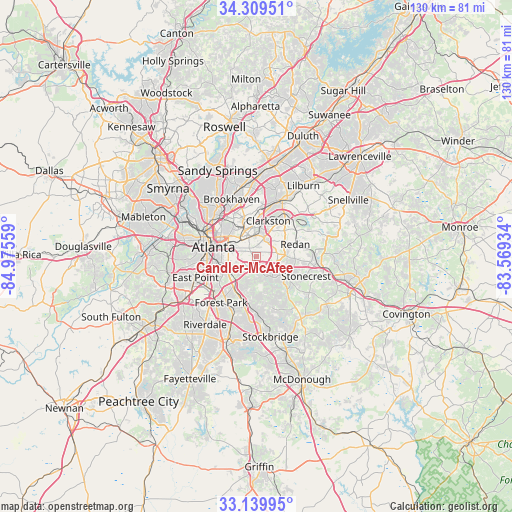
Candler-McAfee GPS coordinates[2]
33° 43' 36.192" North, 84° 16' 20.856" West
| Map corner | latitude | longitude |
|---|---|---|
| Upper-left | 34.30951°, | -84.97559° |
| Center: | 33.72672°, | -84.27246° |
| Lower-right: | 33.13995°, | -83.56934° |
| Map W x H: | 130×130 km | = 80.8×80.8mi |
| max Lat: | 71.29058° ⇑82% North |
| Candler-McAfee: | 33.72672° |
| min Lat: | ⇓18% South 19.06759° |
| min Long | Candler-McAfee | max Long |
| -171.73463° | -84.27246° | -66.98998° |
| W 58.4%⇐ | ⇒41.6% E |
Elevation
Elevation of Candler-McAfee is 291 m = 955 ft, and this is 3.8 m = 12 ft below average elevation for this country.
| Max E: |
3189 m = 10463 ft | 28.9% |
| Avg. | 294.8 m = 967 ft | |
| Candler-McAfee | 291 m = 955 ft | |
Min E: |
-60 m = -197 ft | 71.1% |
See also: United States elevation on elevation.city.
Geographical zone
Candler-McAfee is located in North temperate zone (between Tropic of Cancer and the Arctic Circle). Distance of this Northern Tropic circle is 1144.1 km =710.9 mi to South.| Distance of | km | miles | from Candler-McAfee |
|---|---|---|---|
| North Pole | 6257 | 3887.9 | to North |
| Arctic Circle | 3651.1 | 2268.7 | to North |
| Tropic Cancer | 1144.1 | 710.9 | to South |
| Equator | 3750.1 | 2330.2 | to South |


Nearby cities:
15 places around Candler-McAfee: (largest is in red/bold)
• Atlanta
11 km =6.8 mi,  283°
283°
• Avondale Estates
5 km =3.1 mi,  5°
5°
• Belvedere Park
3.2 km =2 mi, 8°
• Clarkston
9.7 km =6 mi,  18°
18°
• Conley
10.4 km =6.5 mi,  208°
208°
• Decatur
5.8 km =3.6 mi,  337°
337°
• Druid Hills
8.4 km =5.2 mi,  315°
315°
• Gresham Park
4.7 km =2.9 mi,  236°
236°
• North Decatur
7.7 km =4.8 mi, 336°
• North Druid Hills
10.7 km =6.6 mi, 339°
• Panthersville
2.2 km =1.4 mi,  178°
178°
• Pine Lake
9.7 km =6 mi,  39°
39°
• Scottdale
7.1 km =4.4 mi, 6°
• Stone Mountain
13.1 km =8.1 mi,  46°
46°
• Stonecrest
12.9 km =8 mi,  99°
99°
Sources, notices
• [Note1] Compared only with cities in United States existing in our database
• [Src1] Map data: © OpenStreetMap contributors (CC-BY-SA)
• [Src2] Other city data from geonames.org with taken over terms of usage.
• [Src3] Geographical zone / Annual Mean Temperature by Robert A. Rohde @ Wikipedia
