Panthersville geodata
Panthersville (Georgia) is a populated place; located in United States in America/New_York (GMT-4) time zone. With population of 9,749 people, there are 4550 cities with bigger population in this country. Compared to other cities in United States, 82% of cities are located further ↑North; 58.4% of cities are located further ←West and 67.2% of cities have lower elevation than Panthersville. Note1


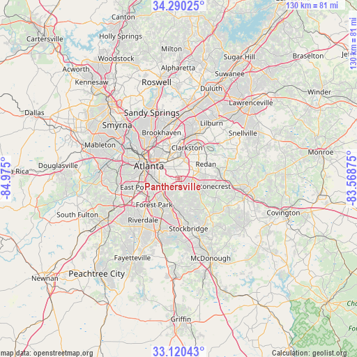
Panthersville GPS coordinates[2]
33° 42' 26.388" North, 84° 16' 18.732" West
| Map corner | latitude | longitude |
|---|---|---|
| Upper-left | 34.29025°, | -84.975° |
| Center: | 33.70733°, | -84.27187° |
| Lower-right: | 33.12043°, | -83.56875° |
| Map W x H: | 130.1×130.1 km | = 80.8×80.8mi |
| max Lat: | 71.29058° ⇑82% North |
| Panthersville: | 33.70733° |
| min Lat: | ⇓18% South 19.06759° |
| min Long | Panthersville | max Long |
| -171.73463° | -84.27187° | -66.98998° |
| W 58.4%⇐ | ⇒41.6% E |
Elevation
Elevation of Panthersville is 272 m = 892 ft, and this is 22.8 m = 75 ft below average elevation for this country.
| Max E: |
3189 m = 10463 ft | 32.8% |
| Avg. | 294.8 m = 967 ft | |
| Panthersville | 272 m = 892 ft | |
Min E: |
-60 m = -197 ft | 67.2% |
See also: United States elevation on elevation.city.
Geographical zone
Panthersville is located in North temperate zone (between Tropic of Cancer and the Arctic Circle). Distance of this Northern Tropic circle is 1142 km =709.6 mi to South.| Distance of | km | miles | from Panthersville |
|---|---|---|---|
| North Pole | 6259.2 | 3889.3 | to North |
| Arctic Circle | 3653.3 | 2270.1 | to North |
| Tropic Cancer | 1142 | 709.6 | to South |
| Equator | 3747.9 | 2328.8 | to South |


Nearby cities:
15 places around Panthersville: (largest is in red/bold)
• Atlanta
11.7 km =7.3 mi,  293°
293°
• Avondale Estates
7.1 km =4.4 mi,  3°
3°
• Belvedere Park
5.3 km =3.3 mi, 4°
• Candler-McAfee
2.2 km =1.4 mi,  358°
358°
• Clarkston
11.7 km =7.3 mi,  14°
14°
• Conley
8.6 km =5.3 mi,  215°
215°
• Decatur
7.8 km =4.8 mi,  343°
343°
• Druid Hills
10.1 km =6.3 mi,  323°
323°
• Gresham Park
4 km =2.5 mi,  263°
263°
• Lake City
12.7 km =7.9 mi,  207°
207°
• North Decatur
9.8 km =6.1 mi, 341°
• North Druid Hills
12.8 km =8 mi, 342°
• Pine Lake
11.4 km =7.1 mi,  32°
32°
• Scottdale
9.2 km =5.7 mi, 4°
• Stonecrest
12.7 km =7.9 mi,  89°
89°
Sources, notices
• [Note1] Compared only with cities in United States existing in our database
• [Src1] Map data: © OpenStreetMap contributors (CC-BY-SA)
• [Src2] Other city data from geonames.org with taken over terms of usage.
• [Src3] Geographical zone / Annual Mean Temperature by Robert A. Rohde @ Wikipedia
