Ellaville geodata
Ellaville (Georgia) is a seat of a second-order administrative division; located in United States in America/New_York (GMT-4) time zone. With population of 1,879 people, there are 12278 cities with bigger population in this country. Compared to other cities in United States, 88% of cities are located further ↑North; 58.2% of cities are located further ←West and 55.5% of cities have higher elevation than Ellaville. Note1


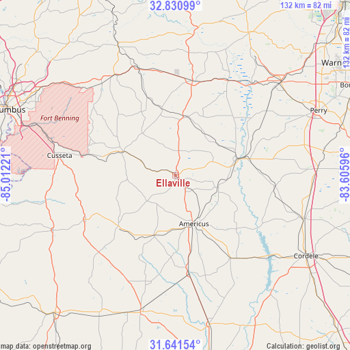
Ellaville GPS coordinates[2]
32° 14' 17.556" North, 84° 18' 32.688" West
| Map corner | latitude | longitude |
|---|---|---|
| Upper-left | 32.83099°, | -85.01221° |
| Center: | 32.23821°, | -84.30908° |
| Lower-right: | 31.64154°, | -83.60596° |
| Map W x H: | 132.3×132.3 km | = 82.2×82.2mi |
| max Lat: | 71.29058° ⇑88% North |
| Ellaville: | 32.23821° |
| min Lat: | ⇓12% South 19.06759° |
| min Long | Ellaville | max Long |
| -171.73463° | -84.30908° | -66.98998° |
| W 58.2%⇐ | ⇒41.8% E |
Elevation
Elevation of Ellaville is 178 m = 584 ft, and this is 116.8 m = 383 ft below average elevation for this country.
| Max E: |
3189 m = 10463 ft | 55.5% |
| Avg. | 294.8 m = 967 ft | |
| Ellaville | 178 m = 584 ft | |
Min E: |
-60 m = -197 ft | 44.5% |
See also: United States elevation on elevation.city.
Geographical zone
Ellaville is located in North temperate zone (between Tropic of Cancer and the Arctic Circle). Distance of this Northern Tropic circle is 978.6 km =608.1 mi to South.| Distance of | km | miles | from Ellaville |
|---|---|---|---|
| North Pole | 6422.5 | 3990.8 | to North |
| Arctic Circle | 3816.6 | 2371.5 | to North |
| Tropic Cancer | 978.6 | 608.1 | to South |
| Equator | 3584.6 | 2227.4 | to South |


Nearby cities:
15 places around Ellaville: (largest is in red/bold)
• Americus
19.8 km =12.3 mi,  158°
158°
• Buena Vista
21.5 km =13.4 mi,  294°
294°
• Butler
36.1 km =22.4 mi,  10°
10°
• Byromville
37.9 km =23.5 mi,  96°
96°
• Cusseta
44.2 km =27.5 mi,  279°
279°
• Lumpkin
50.6 km =31.4 mi,  245°
245°
• Marshallville
42.3 km =26.3 mi,  55°
55°
• Montezuma
27.5 km =17.1 mi,  74°
74°
• Oglethorpe
24.1 km =15 mi,  75°
75°
• Plains
24 km =14.9 mi,  199°
199°
• Preston
28.8 km =17.9 mi,  228°
228°
• Reynolds
41 km =25.5 mi,  29°
29°
• Richland
37.6 km =23.4 mi,  243°
243°
• Smithville
37.9 km =23.5 mi,  171°
171°
• Vienna
51 km =31.7 mi,  108°
108°
Sources, notices
• [Note1] Compared only with cities in United States existing in our database
• [Src1] Map data: © OpenStreetMap contributors (CC-BY-SA)
• [Src2] Other city data from geonames.org with taken over terms of usage.
• [Src3] Geographical zone / Annual Mean Temperature by Robert A. Rohde @ Wikipedia
