Lumpkin geodata
Lumpkin (Georgia) is a seat of a second-order administrative division; located in United States in America/New_York (GMT-4) time zone. With population of 1,093 people, there are 15720 cities with bigger population in this country. Compared to other cities in United States, 88.5% of cities are located further ↑North; 56.3% of cities are located further ←West and 53.1% of cities have higher elevation than Lumpkin. Note1


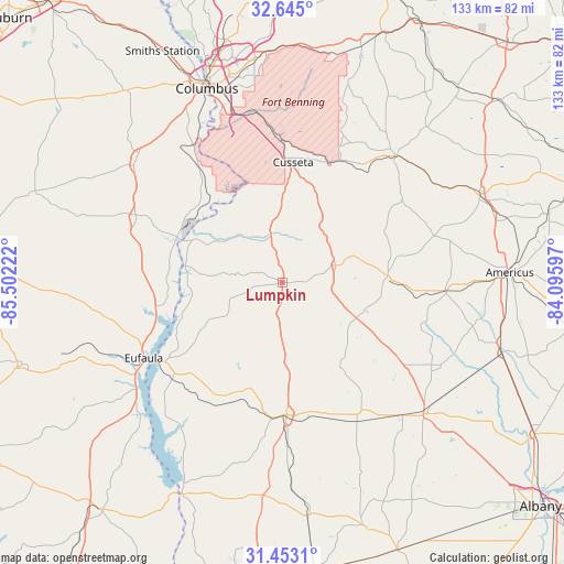
Lumpkin GPS coordinates[2]
32° 3' 3.564" North, 84° 47' 56.724" West
| Map corner | latitude | longitude |
|---|---|---|
| Upper-left | 32.645°, | -85.50222° |
| Center: | 32.05099°, | -84.79909° |
| Lower-right: | 31.4531°, | -84.09597° |
| Map W x H: | 132.5×132.5 km | = 82.3×82.3mi |
| max Lat: | 71.29058° ⇑88.5% North |
| Lumpkin: | 32.05099° |
| min Lat: | ⇓11.5% South 19.06759° |
| min Long | Lumpkin | max Long |
| -171.73463° | -84.79909° | -66.98998° |
| W 56.3%⇐ | ⇒43.7% E |
Elevation
Elevation of Lumpkin is 187 m = 614 ft, and this is 107.8 m = 354 ft below average elevation for this country.
| Max E: |
3189 m = 10463 ft | 53.1% |
| Avg. | 294.8 m = 967 ft | |
| Lumpkin | 187 m = 614 ft | |
Min E: |
-60 m = -197 ft | 46.9% |
See also: United States elevation on elevation.city.
Geographical zone
Lumpkin is located in North temperate zone (between Tropic of Cancer and the Arctic Circle). Distance of this Northern Tropic circle is 957.8 km =595.1 mi to South.| Distance of | km | miles | from Lumpkin |
|---|---|---|---|
| North Pole | 6443.3 | 4003.7 | to North |
| Arctic Circle | 3837.4 | 2384.4 | to North |
| Tropic Cancer | 957.8 | 595.1 | to South |
| Equator | 3563.7 | 2214.4 | to South |


Nearby cities:
15 places around Lumpkin: (largest is in red/bold)
• Bibb City
52.7 km =32.7 mi,  339°
339°
• Buena Vista
39.9 km =24.8 mi,  41°
41°
• Columbus
48.9 km =30.4 mi, 338°
• Cusseta
28.4 km =17.6 mi,  5°
5°
• Cuthbert
31.1 km =19.3 mi,  178°
178°
• Dawson
45.3 km =28.1 mi,  132°
132°
• Ellaville
50.6 km =31.4 mi,  65°
65°
• Eufaula
37.2 km =23.1 mi,  241°
241°
• Georgetown
34.5 km =21.4 mi, 237°
• Ladonia
53.3 km =33.1 mi,  330°
330°
• Phenix City
50.4 km =31.3 mi, 337°
• Plains
38.3 km =23.8 mi,  92°
92°
• Preston
24.7 km =15.3 mi, 86°
• Richland
13.1 km =8.1 mi, 71°
• Shellman
37.1 km =23.1 mi,  152°
152°
Sources, notices
• [Note1] Compared only with cities in United States existing in our database
• [Src1] Map data: © OpenStreetMap contributors (CC-BY-SA)
• [Src2] Other city data from geonames.org with taken over terms of usage.
• [Src3] Geographical zone / Annual Mean Temperature by Robert A. Rohde @ Wikipedia
