Byromville geodata
Byromville (Georgia) is a populated place; located in United States in America/New_York (GMT-4) time zone. With population of 520 people, there are 20628 cities with bigger population in this country. Compared to other cities in United States, 88.1% of cities are located further ↑North; 59.5% of cities are located further ←West and 67.7% of cities have higher elevation than Byromville. Note1


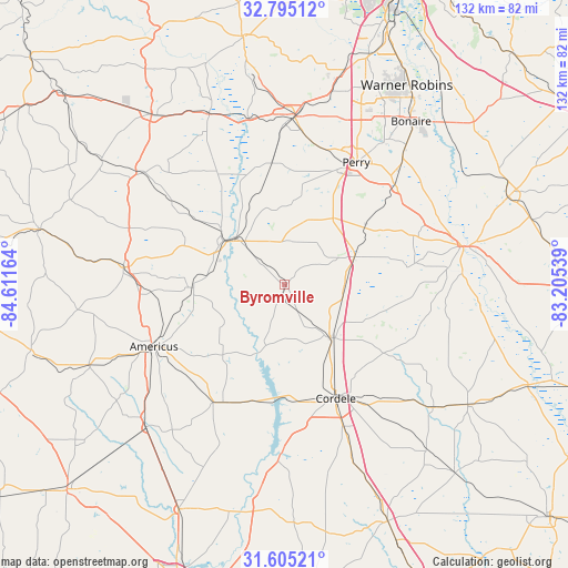
Byromville GPS coordinates[2]
32° 12' 7.596" North, 83° 54' 30.636" West
| Map corner | latitude | longitude |
|---|---|---|
| Upper-left | 32.79512°, | -84.61164° |
| Center: | 32.20211°, | -83.90851° |
| Lower-right: | 31.60521°, | -83.20539° |
| Map W x H: | 132.3×132.3 km | = 82.2×82.2mi |
| max Lat: | 71.29058° ⇑88.1% North |
| Byromville: | 32.20211° |
| min Lat: | ⇓11.9% South 19.06759° |
| min Long | Byromville | max Long |
| -171.73463° | -83.90851° | -66.98998° |
| W 59.5%⇐ | ⇒40.5% E |
Elevation
Elevation of Byromville is 114 m = 374 ft, and this is 180.8 m = 593 ft below average elevation for this country.
| Max E: |
3189 m = 10463 ft | 67.7% |
| Avg. | 294.8 m = 967 ft | |
| Byromville | 114 m = 374 ft | |
Min E: |
-60 m = -197 ft | 32.3% |
See also: United States elevation on elevation.city.
Geographical zone
Byromville is located in North temperate zone (between Tropic of Cancer and the Arctic Circle). Distance of this Northern Tropic circle is 974.6 km =605.6 mi to South.| Distance of | km | miles | from Byromville |
|---|---|---|---|
| North Pole | 6426.5 | 3993.2 | to North |
| Arctic Circle | 3820.6 | 2374 | to North |
| Tropic Cancer | 974.6 | 605.6 | to South |
| Equator | 3580.5 | 2224.8 | to South |


Nearby cities:
15 places around Byromville: (largest is in red/bold)
• Americus
33.8 km =21 mi,  244°
244°
• Arabi
44.2 km =27.5 mi,  158°
158°
• Cordele
29.1 km =18.1 mi, 155°
• Ellaville
37.9 km =23.5 mi,  276°
276°
• Fort Valley
39.1 km =24.3 mi,  2°
2°
• Hawkinsville
42 km =26.1 mi,  77°
77°
• Marshallville
28.4 km =17.6 mi,  353°
353°
• Montezuma
16 km =9.9 mi,  315°
315°
• Oglethorpe
17.6 km =10.9 mi,  305°
305°
• Perry
33 km =20.5 mi,  30°
30°
• Pineview
39.7 km =24.7 mi,  104°
104°
• Reynolds
43.5 km =27 mi,  336°
336°
• Smithville
46.6 km =29 mi,  223°
223°
• Unadilla
17.5 km =10.9 mi,  67°
67°
• Vienna
16.3 km =10.1 mi,  139°
139°
Sources, notices
• [Note1] Compared only with cities in United States existing in our database
• [Src1] Map data: © OpenStreetMap contributors (CC-BY-SA)
• [Src2] Other city data from geonames.org with taken over terms of usage.
• [Src3] Geographical zone / Annual Mean Temperature by Robert A. Rohde @ Wikipedia
