Hawkinsville geodata
Hawkinsville (Georgia) is a seat of a second-order administrative division; located in United States in America/New_York (GMT-4) time zone. With population of 5,471 people, there are 6784 cities with bigger population in this country. Compared to other cities in United States, 87.9% of cities are located further ↑North; 60.7% of cities are located further ←West and 72.5% of cities have higher elevation than Hawkinsville. Note1


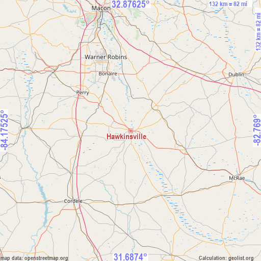
Hawkinsville GPS coordinates[2]
32° 17' 1.572" North, 83° 28' 19.632" West
| Map corner | latitude | longitude |
|---|---|---|
| Upper-left | 32.87625°, | -84.17525° |
| Center: | 32.28377°, | -83.47212° |
| Lower-right: | 31.6874°, | -82.769° |
| Map W x H: | 132.2×132.2 km | = 82.1×82.1mi |
| max Lat: | 71.29058° ⇑87.9% North |
| Hawkinsville: | 32.28377° |
| min Lat: | ⇓12.1% South 19.06759° |
| min Long | Hawkinsville | max Long |
| -171.73463° | -83.47212° | -66.98998° |
| W 60.7%⇐ | ⇒39.3% E |
Elevation
Elevation of Hawkinsville is 86 m = 282 ft, and this is 208.8 m = 685 ft below average elevation for this country.
| Max E: |
3189 m = 10463 ft | 72.5% |
| Avg. | 294.8 m = 967 ft | |
| Hawkinsville | 86 m = 282 ft | |
Min E: |
-60 m = -197 ft | 27.5% |
See also: United States elevation on elevation.city.
Geographical zone
Hawkinsville is located in North temperate zone (between Tropic of Cancer and the Arctic Circle). Distance of this Northern Tropic circle is 983.7 km =611.2 mi to South.| Distance of | km | miles | from Hawkinsville |
|---|---|---|---|
| North Pole | 6417.4 | 3987.6 | to North |
| Arctic Circle | 3811.6 | 2368.4 | to North |
| Tropic Cancer | 983.7 | 611.2 | to South |
| Equator | 3589.6 | 2230.5 | to South |


Nearby cities:
15 places around Hawkinsville: (largest is in red/bold)
• Abbeville
36 km =22.4 mi,  154°
154°
• Byromville
42 km =26.1 mi,  257°
257°
• Cadwell
40.9 km =25.4 mi,  81°
81°
• Centerville
43.6 km =27.1 mi,  332°
332°
• Chester
32.4 km =20.1 mi,  67°
67°
• Cochran
15.9 km =9.9 mi,  43°
43°
• Dexter
42 km =26.1 mi, 66°
• Eastman
29.3 km =18.2 mi,  109°
109°
• Perry
31.1 km =19.3 mi,  308°
308°
• Pineview
19.5 km =12.1 mi,  188°
188°
• Robins Air Force Base
37.7 km =23.4 mi,  343°
343°
• Rochelle
37 km =23 mi,  177°
177°
• Unadilla
25 km =15.5 mi, 264°
• Vienna
37.2 km =23.1 mi,  234°
234°
• Warner Robins
39.7 km =24.7 mi, 338°
Sources, notices
• [Note1] Compared only with cities in United States existing in our database
• [Src1] Map data: © OpenStreetMap contributors (CC-BY-SA)
• [Src2] Other city data from geonames.org with taken over terms of usage.
• [Src3] Geographical zone / Annual Mean Temperature by Robert A. Rohde @ Wikipedia
