Perry geodata
Perry (Georgia) is a seat of a second-order administrative division; located in United States in America/New_York (GMT-4) time zone. With population of 15,457 people, there are 3153 cities with bigger population in this country. Compared to other cities in United States, 87.3% of cities are located further ↑North; 60% of cities are located further ←West and 67.9% of cities have higher elevation than Perry. Note1


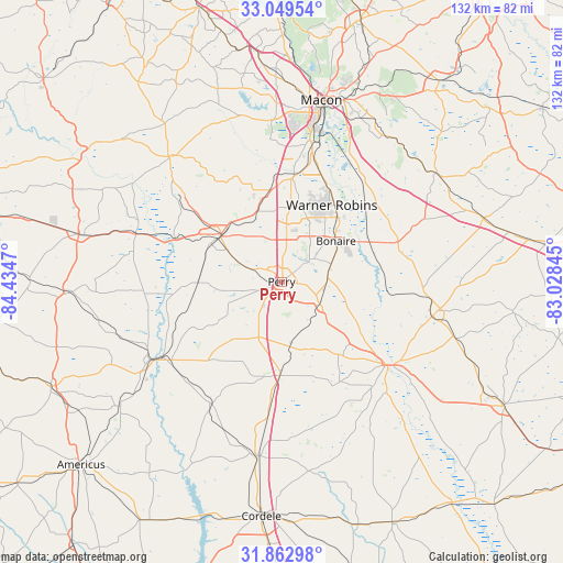
Perry GPS coordinates[2]
32° 27' 29.556" North, 83° 43' 53.652" West
| Map corner | latitude | longitude |
|---|---|---|
| Upper-left | 33.04954°, | -84.4347° |
| Center: | 32.45821°, | -83.73157° |
| Lower-right: | 31.86298°, | -83.02845° |
| Map W x H: | 131.9×131.9 km | = 82×82mi |
| max Lat: | 71.29058° ⇑87.3% North |
| Perry: | 32.45821° |
| min Lat: | ⇓12.7% South 19.06759° |
| min Long | Perry | max Long |
| -171.73463° | -83.73157° | -66.98998° |
| W 60%⇐ | ⇒40% E |
Elevation
Elevation of Perry is 113 m = 371 ft, and this is 181.8 m = 596 ft below average elevation for this country.
| Max E: |
3189 m = 10463 ft | 67.9% |
| Avg. | 294.8 m = 967 ft | |
| Perry | 113 m = 371 ft | |
Min E: |
-60 m = -197 ft | 32.1% |
See also: United States elevation on elevation.city.
Geographical zone
Perry is located in North temperate zone (between Tropic of Cancer and the Arctic Circle). Distance of this Northern Tropic circle is 1003.1 km =623.3 mi to South.| Distance of | km | miles | from Perry |
|---|---|---|---|
| North Pole | 6398 | 3975.5 | to North |
| Arctic Circle | 3792.2 | 2356.4 | to North |
| Tropic Cancer | 1003.1 | 623.3 | to South |
| Equator | 3609 | 2242.5 | to South |


Nearby cities:
15 places around Perry: (largest is in red/bold)
• Byromville
33 km =20.5 mi,  210°
210°
• Byron
21.9 km =13.6 mi,  353°
353°
• Centerville
19.5 km =12.1 mi,  11°
11°
• Cochran
36.3 km =22.6 mi,  102°
102°
• Fort Valley
18.1 km =11.2 mi,  306°
306°
• Hawkinsville
31.1 km =19.3 mi,  128°
128°
• Knoxville
38.7 km =24 mi,  319°
319°
• Marshallville
19.6 km =12.2 mi,  269°
269°
• Montezuma
32.6 km =20.3 mi,  238°
238°
• Oglethorpe
35.9 km =22.3 mi, 239°
• Reynolds
36 km =22.4 mi,  288°
288°
• Robins Air Force Base
21.7 km =13.5 mi,  39°
39°
• Unadilla
21.9 km =13.6 mi,  181°
181°
• Warner Robins
20.1 km =12.5 mi,  29°
29°
• West Point
37.9 km =23.5 mi, 349°
Sources, notices
• [Note1] Compared only with cities in United States existing in our database
• [Src1] Map data: © OpenStreetMap contributors (CC-BY-SA)
• [Src2] Other city data from geonames.org with taken over terms of usage.
• [Src3] Geographical zone / Annual Mean Temperature by Robert A. Rohde @ Wikipedia
