Chester geodata
Chester (Georgia) is a populated place; located in United States in America/New_York (GMT-4) time zone. With population of 1,568 people, there are 13408 cities with bigger population in this country. Compared to other cities in United States, 87.5% of cities are located further ↑North; 61.6% of cities are located further ←West and 67.7% of cities have higher elevation than Chester. Note1


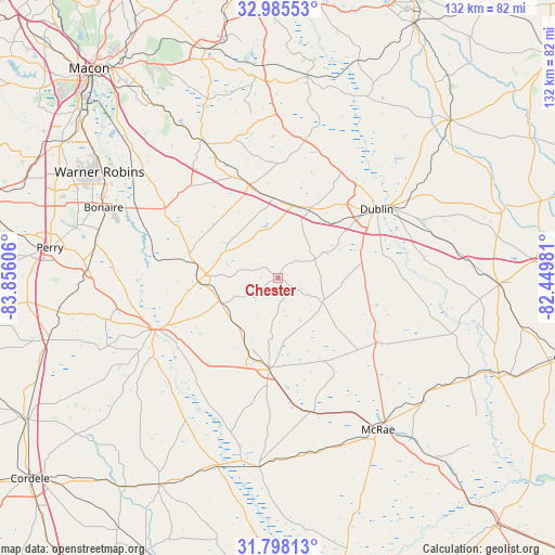
Chester GPS coordinates[2]
32° 23' 37.608" North, 83° 9' 10.548" West
| Map corner | latitude | longitude |
|---|---|---|
| Upper-left | 32.98553°, | -83.85606° |
| Center: | 32.39378°, | -83.15293° |
| Lower-right: | 31.79813°, | -82.44981° |
| Map W x H: | 132×132 km | = 82×82mi |
| max Lat: | 71.29058° ⇑87.5% North |
| Chester: | 32.39378° |
| min Lat: | ⇓12.5% South 19.06759° |
| min Long | Chester | max Long |
| -171.73463° | -83.15293° | -66.98998° |
| W 61.6%⇐ | ⇒38.4% E |
Elevation
Elevation of Chester is 114 m = 374 ft, and this is 180.8 m = 593 ft below average elevation for this country.
| Max E: |
3189 m = 10463 ft | 67.7% |
| Avg. | 294.8 m = 967 ft | |
| Chester | 114 m = 374 ft | |
Min E: |
-60 m = -197 ft | 32.3% |
See also: United States elevation on elevation.city.
Geographical zone
Chester is located in North temperate zone (between Tropic of Cancer and the Arctic Circle). Distance of this Northern Tropic circle is 995.9 km =618.8 mi to South.| Distance of | km | miles | from Chester |
|---|---|---|---|
| North Pole | 6405.2 | 3980 | to North |
| Arctic Circle | 3799.3 | 2360.8 | to North |
| Tropic Cancer | 995.9 | 618.8 | to South |
| Equator | 3601.9 | 2238.1 | to South |


Nearby cities:
15 places around Chester: (largest is in red/bold)
• Alamo
44.7 km =27.8 mi,  127°
127°
• Cadwell
12 km =7.5 mi,  120°
120°
• Cochran
19 km =11.8 mi,  267°
267°
• Dexter
9.6 km =6 mi,  63°
63°
• Dublin
28.5 km =17.7 mi, 55°
• Dudley
18.2 km =11.3 mi,  25°
25°
• East Dublin
31.5 km =19.6 mi, 56°
• Eastman
21.9 km =13.6 mi,  186°
186°
• Hawkinsville
32.4 km =20.1 mi,  247°
247°
• Helena
42.1 km =26.2 mi,  147°
147°
• Irwinton
46.5 km =28.9 mi,  357°
357°
• Jeffersonville
37.4 km =23.2 mi,  330°
330°
• McRae
43.3 km =26.9 mi, 146°
• Milan
42.7 km =26.5 mi,  168°
168°
• Pineview
45.4 km =28.2 mi,  226°
226°
Sources, notices
• [Note1] Compared only with cities in United States existing in our database
• [Src1] Map data: © OpenStreetMap contributors (CC-BY-SA)
• [Src2] Other city data from geonames.org with taken over terms of usage.
• [Src3] Geographical zone / Annual Mean Temperature by Robert A. Rohde @ Wikipedia
