Locust Grove geodata
Locust Grove (Georgia) is a populated place; located in United States in America/New_York (GMT-4) time zone. With population of 5,790 people, there are 6552 cities with bigger population in this country. Compared to other cities in United States, 83.8% of cities are located further ↑North; 59% of cities are located further ←West and 64.1% of cities have lower elevation than Locust Grove. Note1


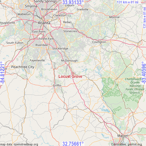
Locust Grove GPS coordinates[2]
33° 20' 45.42" North, 84° 6' 32.688" West
| Map corner | latitude | longitude |
|---|---|---|
| Upper-left | 33.93133°, | -84.81221° |
| Center: | 33.34595°, | -84.10908° |
| Lower-right: | 32.75661°, | -83.40596° |
| Map W x H: | 130.6×130.6 km | = 81.2×81.2mi |
| max Lat: | 71.29058° ⇑83.8% North |
| Locust Grove: | 33.34595° |
| min Lat: | ⇓16.2% South 19.06759° |
| min Long | Locust Grove | max Long |
| -171.73463° | -84.10908° | -66.98998° |
| W 59%⇐ | ⇒41% E |
Elevation
Elevation of Locust Grove is 258 m = 846 ft, and this is 36.8 m = 121 ft below average elevation for this country.
| Max E: |
3189 m = 10463 ft | 35.9% |
| Avg. | 294.8 m = 967 ft | |
| Locust Grove | 258 m = 846 ft | |
Min E: |
-60 m = -197 ft | 64.1% |
See also: United States elevation on elevation.city.
Geographical zone
Locust Grove is located in North temperate zone (between Tropic of Cancer and the Arctic Circle). Distance of this Northern Tropic circle is 1101.8 km =684.6 mi to South.| Distance of | km | miles | from Locust Grove |
|---|---|---|---|
| North Pole | 6299.3 | 3914.2 | to North |
| Arctic Circle | 3693.5 | 2295 | to North |
| Tropic Cancer | 1101.8 | 684.6 | to South |
| Equator | 3707.7 | 2303.9 | to South |


Nearby cities:
15 places around Locust Grove: (largest is in red/bold)
• Bonanza
25 km =15.5 mi,  302°
302°
• East Griffin
15.9 km =9.9 mi,  224°
224°
• Experiment
18.4 km =11.4 mi,  240°
240°
• Flovilla
22.1 km =13.7 mi,  117°
117°
• Griffin
18.1 km =11.2 mi,  232°
232°
• Hampton
16.8 km =10.4 mi,  285°
285°
• Indian Springs
20.9 km =13 mi, 123°
• Irondale
27.6 km =17.1 mi, 302°
• Jackson
14.5 km =9 mi,  113°
113°
• Jonesboro
29.9 km =18.6 mi,  310°
310°
• Lovejoy
21.5 km =13.4 mi, 297°
• McDonough
11.8 km =7.3 mi,  342°
342°
• Milner
26.7 km =16.6 mi,  197°
197°
• Oakwood
25.7 km =16 mi,  29°
29°
• Stockbridge
24.9 km =15.5 mi,  332°
332°
Sources, notices
• [Note1] Compared only with cities in United States existing in our database
• [Src1] Map data: © OpenStreetMap contributors (CC-BY-SA)
• [Src2] Other city data from geonames.org with taken over terms of usage.
• [Src3] Geographical zone / Annual Mean Temperature by Robert A. Rohde @ Wikipedia
