Griffin geodata
Griffin (Georgia) is a seat of a second-order administrative division; located in United States in America/New_York (GMT-4) time zone. With population of 23,211 people, there are 2169 cities with bigger population in this country. Compared to other cities in United States, 84.1% of cities are located further ↑North; 58.4% of cities are located further ←West and 73.3% of cities have lower elevation than Griffin. Note1


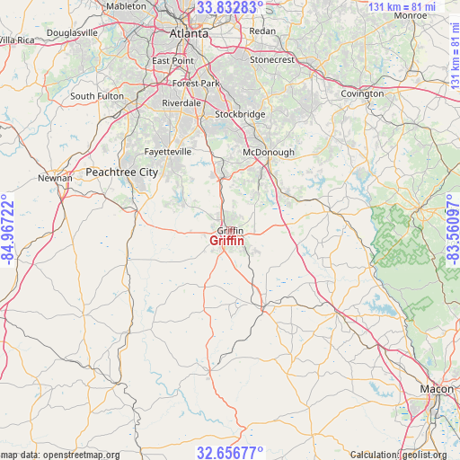
Griffin GPS coordinates[2]
33° 14' 48.408" North, 84° 15' 50.724" West
| Map corner | latitude | longitude |
|---|---|---|
| Upper-left | 33.83283°, | -84.96722° |
| Center: | 33.24678°, | -84.26409° |
| Lower-right: | 32.65677°, | -83.56097° |
| Map W x H: | 130.8×130.8 km | = 81.3×81.3mi |
| max Lat: | 71.29058° ⇑84.1% North |
| Griffin: | 33.24678° |
| min Lat: | ⇓15.9% South 19.06759° |
| min Long | Griffin | max Long |
| -171.73463° | -84.26409° | -66.98998° |
| W 58.4%⇐ | ⇒41.6% E |
Elevation
Elevation of Griffin is 303 m = 994 ft, and this is 8.2 m = 27 ft above average elevation for this country.
| Max E: |
3189 m = 10463 ft | 26.7% |
| Griffin | 303 m 994 ft | |
| Avg. | 294.8 m = 967 ft | |
Min E: |
-60 m = -197 ft | 73.3% |
See also: United States elevation on elevation.city.
Geographical zone
Griffin is located in North temperate zone (between Tropic of Cancer and the Arctic Circle). Distance of this Northern Tropic circle is 1090.8 km =677.8 mi to South.| Distance of | km | miles | from Griffin |
|---|---|---|---|
| North Pole | 6310.4 | 3921.1 | to North |
| Arctic Circle | 3704.5 | 2301.9 | to North |
| Tropic Cancer | 1090.8 | 677.8 | to South |
| Equator | 3696.7 | 2297 | to South |


Nearby cities:
15 places around Griffin: (largest is in red/bold)
• Barnesville
23.6 km =14.7 mi,  154°
154°
• Bonanza
25.3 km =15.7 mi,  344°
344°
• Brooks
18.8 km =11.7 mi,  285°
285°
• East Griffin
3.3 km =2.1 mi,  95°
95°
• Experiment
2.6 km =1.6 mi,  321°
321°
• Hampton
15.7 km =9.8 mi,  353°
353°
• Irondale
27.5 km =17.1 mi, 341°
• Jackson
28.2 km =17.5 mi,  79°
79°
• Locust Grove
18.1 km =11.2 mi,  52°
52°
• Lovejoy
21.6 km =13.4 mi, 347°
• McDonough
24.8 km =15.4 mi,  26°
26°
• Milner
15.8 km =9.8 mi,  156°
156°
• Senoia
27.6 km =17.1 mi,  282°
282°
• Shannon
25.8 km =16 mi,  312°
312°
• Zebulon
17.6 km =10.9 mi,  204°
204°
Sources, notices
• [Note1] Compared only with cities in United States existing in our database
• [Src1] Map data: © OpenStreetMap contributors (CC-BY-SA)
• [Src2] Other city data from geonames.org with taken over terms of usage.
• [Src3] Geographical zone / Annual Mean Temperature by Robert A. Rohde @ Wikipedia
