Jackson geodata
Jackson (Georgia) is a seat of a second-order administrative division; located in United States in America/New_York (GMT-4) time zone. With population of 4,983 people, there are 7196 cities with bigger population in this country. Compared to other cities in United States, 84% of cities are located further ↑North; 59.4% of cities are located further ←West and 55.1% of cities have lower elevation than Jackson. Note1


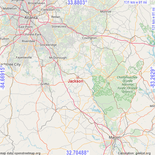
Jackson GPS coordinates[2]
33° 17' 40.452" North, 83° 57' 57.672" West
| Map corner | latitude | longitude |
|---|---|---|
| Upper-left | 33.8803°, | -84.66915° |
| Center: | 33.29457°, | -83.96602° |
| Lower-right: | 32.70488°, | -83.2629° |
| Map W x H: | 130.7×130.7 km | = 81.2×81.2mi |
| max Lat: | 71.29058° ⇑84% North |
| Jackson: | 33.29457° |
| min Lat: | ⇓16% South 19.06759° |
| min Long | Jackson | max Long |
| -171.73463° | -83.96602° | -66.98998° |
| W 59.4%⇐ | ⇒40.6% E |
Elevation
Elevation of Jackson is 219 m = 719 ft, and this is 75.8 m = 249 ft below average elevation for this country.
| Max E: |
3189 m = 10463 ft | 44.9% |
| Avg. | 294.8 m = 967 ft | |
| Jackson | 219 m = 719 ft | |
Min E: |
-60 m = -197 ft | 55.1% |
See also: United States elevation on elevation.city.
Geographical zone
Jackson is located in North temperate zone (between Tropic of Cancer and the Arctic Circle). Distance of this Northern Tropic circle is 1096.1 km =681.1 mi to South.| Distance of | km | miles | from Jackson |
|---|---|---|---|
| North Pole | 6305.1 | 3917.8 | to North |
| Arctic Circle | 3699.2 | 2298.6 | to North |
| Tropic Cancer | 1096.1 | 681.1 | to South |
| Equator | 3702 | 2300.3 | to South |


Nearby cities:
15 places around Jackson: (largest is in red/bold)
• Barnesville
32 km =19.9 mi,  213°
213°
• Covington
35 km =21.7 mi,  16°
16°
• East Griffin
25.1 km =15.6 mi,  256°
256°
• Experiment
29.5 km =18.3 mi, 263°
• Flovilla
7.7 km =4.8 mi,  125°
125°
• Forsyth
29.1 km =18.1 mi,  174°
174°
• Griffin
28.2 km =17.5 mi, 259°
• Hampton
31.2 km =19.4 mi,  289°
289°
• Indian Springs
7.1 km =4.4 mi,  143°
143°
• Locust Grove
14.5 km =9 mi, 293°
• McDonough
23.9 km =14.9 mi,  315°
315°
• Milner
29.2 km =18.1 mi,  227°
227°
• Monticello
26.3 km =16.3 mi,  87°
87°
• Oakwood
28.2 km =17.5 mi,  358°
358°
• Porterdale
31.9 km =19.8 mi,  12°
12°
Sources, notices
• [Note1] Compared only with cities in United States existing in our database
• [Src1] Map data: © OpenStreetMap contributors (CC-BY-SA)
• [Src2] Other city data from geonames.org with taken over terms of usage.
• [Src3] Geographical zone / Annual Mean Temperature by Robert A. Rohde @ Wikipedia
