Moody A F B geodata
Moody A F B (Georgia) is a populated place; located in United States in America/New_York (GMT-4) time zone. With population of 886 people, there are 17069 cities with bigger population in this country. Compared to other cities in United States, 90.8% of cities are located further ↑North; 61.4% of cities are located further ←West and 74.6% of cities have higher elevation than Moody A F B. Note1


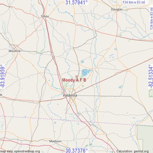
Moody A F B GPS coordinates[2]
30° 58' 42.564" North, 83° 12' 59.256" West
| Map corner | latitude | longitude |
|---|---|---|
| Upper-left | 31.57941°, | -83.91959° |
| Center: | 30.97849°, | -83.21646° |
| Lower-right: | 30.37376°, | -82.51334° |
| Map W x H: | 134.1×134.1 km | = 83.3×83.3mi |
| max Lat: | 71.29058° ⇑90.8% North |
| Moody A F B: | 30.97849° |
| min Lat: | ⇓9.2% South 19.06759° |
| min Long | Moody A F B | max Long |
| -171.73463° | -83.21646° | -66.98998° |
| W 61.4%⇐ | ⇒38.6% E |
Elevation
Elevation of Moody A F B is 74 m = 243 ft, and this is 220.8 m = 724 ft below average elevation for this country.
| Max E: |
3189 m = 10463 ft | 74.6% |
| Avg. | 294.8 m = 967 ft | |
| Moody A F B | 74 m = 243 ft | |
Min E: |
-60 m = -197 ft | 25.4% |
See also: United States elevation on elevation.city.
Geographical zone
Moody A F B is located in North temperate zone (between Tropic of Cancer and the Arctic Circle). Distance of this Northern Tropic circle is 838.6 km =521.1 mi to South.| Distance of | km | miles | from Moody A F B |
|---|---|---|---|
| North Pole | 6562.6 | 4077.8 | to North |
| Arctic Circle | 3956.7 | 2458.6 | to North |
| Tropic Cancer | 838.6 | 521.1 | to South |
| Equator | 3444.5 | 2140.3 | to South |


Nearby cities:
15 places around Moody A F B: (largest is in red/bold)
• Adel
26.5 km =16.5 mi,  311°
311°
• Berlin
40.1 km =24.9 mi,  284°
284°
• Dasher
25.7 km =16 mi,  180°
180°
• Hahira
15 km =9.3 mi, 275°
• Lake Park
33.1 km =20.6 mi,  173°
173°
• Lakeland
15.2 km =9.4 mi,  62°
62°
• Lenox
40.3 km =25 mi,  324°
324°
• Morven
27.3 km =17 mi,  261°
261°
• Nashville
25.7 km =16 mi,  352°
352°
• Quitman
39.2 km =24.4 mi,  236°
236°
• Ray City
10.8 km =6.7 mi,  8°
8°
• Remerton
17.4 km =10.8 mi,  210°
210°
• Sparks
29.7 km =18.5 mi, 314°
• Statenville
35.5 km =22.1 mi,  149°
149°
• Valdosta
17.3 km =10.7 mi,  200°
200°
Sources, notices
• [Note1] Compared only with cities in United States existing in our database
• [Src1] Map data: © OpenStreetMap contributors (CC-BY-SA)
• [Src2] Other city data from geonames.org with taken over terms of usage.
• [Src3] Geographical zone / Annual Mean Temperature by Robert A. Rohde @ Wikipedia
