Valdosta geodata
Valdosta (Georgia) is a seat of a second-order administrative division; located in United States in America/New_York (GMT-4) time zone. With population of 55,724 people, there are 821 cities with bigger population in this country. Compared to other cities in United States, 91% of cities are located further ↑North; 61.2% of cities are located further ←West and 75.1% of cities have higher elevation than Valdosta. Note1


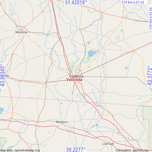
Valdosta GPS coordinates[2]
30° 50' 0.024" North, 83° 16' 49.152" West
| Map corner | latitude | longitude |
|---|---|---|
| Upper-left | 31.43518°, | -83.98345° |
| Center: | 30.83334°, | -83.28032° |
| Lower-right: | 30.2277°, | -82.5772° |
| Map W x H: | 134.3×134.3 km | = 83.5×83.5mi |
| max Lat: | 71.29058° ⇑91% North |
| Valdosta: | 30.83334° |
| min Lat: | ⇓9% South 19.06759° |
| min Long | Valdosta | max Long |
| -171.73463° | -83.28032° | -66.98998° |
| W 61.2%⇐ | ⇒38.8% E |
Elevation
Elevation of Valdosta is 71 m = 233 ft, and this is 223.8 m = 734 ft below average elevation for this country.
| Max E: |
3189 m = 10463 ft | 75.1% |
| Avg. | 294.8 m = 967 ft | |
| Valdosta | 71 m = 233 ft | |
Min E: |
-60 m = -197 ft | 24.9% |
See also: Valdosta elevation on elevation.city.
Geographical zone
Valdosta is located in North temperate zone (between Tropic of Cancer and the Arctic Circle). Distance of this Northern Tropic circle is 822.4 km =511 mi to South.| Distance of | km | miles | from Valdosta |
|---|---|---|---|
| North Pole | 6578.7 | 4087.8 | to North |
| Arctic Circle | 3972.8 | 2468.6 | to North |
| Tropic Cancer | 822.4 | 511 | to South |
| Equator | 3428.3 | 2130.2 | to South |


Nearby cities:
15 places around Valdosta: (largest is in red/bold)
• Adel
36.5 km =22.7 mi,  337°
337°
• Berlin
41.9 km =26 mi,  308°
308°
• Dasher
11.1 km =6.9 mi,  149°
149°
• Hahira
19.6 km =12.2 mi,  333°
333°
• Jennings
30.9 km =19.2 mi, 145°
• Lake Park
19.4 km =12.1 mi, 150°
• Lakeland
30.3 km =18.8 mi,  40°
40°
• Moody A F B
17.3 km =10.7 mi,  20°
20°
• Morven
24.1 km =15 mi,  299°
299°
• Nashville
41.7 km =25.9 mi,  3°
3°
• Quitman
27.2 km =16.9 mi,  258°
258°
• Ray City
27.9 km =17.3 mi, 16°
• Remerton
3.1 km =1.9 mi,  292°
292°
• Sparks
40 km =24.9 mi, 338°
• Statenville
28.1 km =17.5 mi,  120°
120°
Sources, notices
• [Note1] Compared only with cities in United States existing in our database
• [Src1] Map data: © OpenStreetMap contributors (CC-BY-SA)
• [Src2] Other city data from geonames.org with taken over terms of usage.
• [Src3] Geographical zone / Annual Mean Temperature by Robert A. Rohde @ Wikipedia
