Nashville geodata
Nashville (Georgia) is a seat of a second-order administrative division; located in United States in America/New_York (GMT-4) time zone. With population of 4,854 people, there are 7313 cities with bigger population in this country. Compared to other cities in United States, 90.3% of cities are located further ↑North; 61.3% of cities are located further ←West and 74% of cities have higher elevation than Nashville. Note1


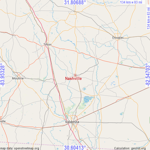
Nashville GPS coordinates[2]
31° 12' 26.712" North, 83° 15' 0.54" West
| Map corner | latitude | longitude |
|---|---|---|
| Upper-left | 31.80688°, | -83.95328° |
| Center: | 31.20742°, | -83.25015° |
| Lower-right: | 30.60413°, | -82.54703° |
| Map W x H: | 133.7×133.7 km | = 83.1×83.1mi |
| max Lat: | 71.29058° ⇑90.3% North |
| Nashville: | 31.20742° |
| min Lat: | ⇓9.7% South 19.06759° |
| min Long | Nashville | max Long |
| -171.73463° | -83.25015° | -66.98998° |
| W 61.3%⇐ | ⇒38.7% E |
Elevation
Elevation of Nashville is 77 m = 253 ft, and this is 217.8 m = 715 ft below average elevation for this country.
| Max E: |
3189 m = 10463 ft | 74% |
| Avg. | 294.8 m = 967 ft | |
| Nashville | 77 m = 253 ft | |
Min E: |
-60 m = -197 ft | 26% |
See also: United States elevation on elevation.city.
Geographical zone
Nashville is located in North temperate zone (between Tropic of Cancer and the Arctic Circle). Distance of this Northern Tropic circle is 864 km =536.9 mi to South.| Distance of | km | miles | from Nashville |
|---|---|---|---|
| North Pole | 6537.1 | 4062 | to North |
| Arctic Circle | 3931.2 | 2442.7 | to North |
| Tropic Cancer | 864 | 536.9 | to South |
| Equator | 3469.9 | 2156.1 | to South |


Nearby cities:
15 places around Nashville: (largest is in red/bold)
• Adel
18.3 km =11.4 mi,  244°
244°
• Alapaha
19.9 km =12.4 mi,  7°
7°
• Enigma
24.1 km =15 mi,  341°
341°
• Hahira
26.7 km =16.6 mi,  205°
205°
• Lakeland
24.9 km =15.5 mi,  138°
138°
• Lenox
21.6 km =13.4 mi,  289°
289°
• Moody A F B
25.7 km =16 mi,  172°
172°
• Morven
37.9 km =23.5 mi,  218°
218°
• Omega
35.9 km =22.3 mi, 294°
• Phillipsburg
36.3 km =22.6 mi,  315°
315°
• Ray City
15.5 km =9.6 mi,  161°
161°
• Sparks
18.4 km =11.4 mi,  255°
255°
• Tifton
36.5 km =22.7 mi, 317°
• Unionville
35.3 km =21.9 mi, 315°
• Willacoochee
24.4 km =15.2 mi,  52°
52°
Sources, notices
• [Note1] Compared only with cities in United States existing in our database
• [Src1] Map data: © OpenStreetMap contributors (CC-BY-SA)
• [Src2] Other city data from geonames.org with taken over terms of usage.
• [Src3] Geographical zone / Annual Mean Temperature by Robert A. Rohde @ Wikipedia
