Stonecrest geodata
Stonecrest (Georgia) is a populated place; located in United States in America/New_York (GMT-4) time zone. With population of 50,000 people, there are 950 cities with bigger population in this country. Compared to other cities in United States, 82% of cities are located further ↑North; 58.9% of cities are located further ←West and 62.8% of cities have lower elevation than Stonecrest. Note1


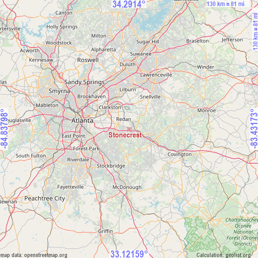
Stonecrest GPS coordinates[2]
33° 42' 30.564" North, 84° 8' 5.46" West
| Map corner | latitude | longitude |
|---|---|---|
| Upper-left | 34.2914°, | -84.83798° |
| Center: | 33.70849°, | -84.13485° |
| Lower-right: | 33.12159°, | -83.43173° |
| Map W x H: | 130.1×130.1 km | = 80.8×80.8mi |
| max Lat: | 71.29058° ⇑82% North |
| Stonecrest: | 33.70849° |
| min Lat: | ⇓18% South 19.06759° |
| min Long | Stonecrest | max Long |
| -171.73463° | -84.13485° | -66.98998° |
| W 58.9%⇐ | ⇒41.1% E |
Elevation
Elevation of Stonecrest is 252 m = 827 ft, and this is 42.8 m = 140 ft below average elevation for this country.
| Max E: |
3189 m = 10463 ft | 37.2% |
| Avg. | 294.8 m = 967 ft | |
| Stonecrest | 252 m = 827 ft | |
Min E: |
-60 m = -197 ft | 62.8% |
See also: Stonecrest elevation on elevation.city.
Geographical zone
Stonecrest is located in North temperate zone (between Tropic of Cancer and the Arctic Circle). Distance of this Northern Tropic circle is 1142.1 km =709.7 mi to South.| Distance of | km | miles | from Stonecrest |
|---|---|---|---|
| North Pole | 6259 | 3889.2 | to North |
| Arctic Circle | 3653.1 | 2269.9 | to North |
| Tropic Cancer | 1142.1 | 709.7 | to South |
| Equator | 3748 | 2328.9 | to South |


Nearby cities:
15 places around Stonecrest: (largest is in red/bold)
• Avondale Estates
14.1 km =8.8 mi,  299°
299°
• Belvedere Park
13.3 km =8.3 mi,  292°
292°
• Candler-McAfee
12.9 km =8 mi,  279°
279°
• Clarkston
14.8 km =9.2 mi,  319°
319°
• Conyers
11.8 km =7.3 mi,  112°
112°
• Gresham Park
16.6 km =10.3 mi,  268°
268°
• Lakeview Estates
9.6 km =6 mi,  91°
91°
• Lithonia
2.8 km =1.7 mi,  81°
81°
• Mountain Park
15.1 km =9.4 mi,  1°
1°
• Panthersville
12.7 km =7.9 mi, 269°
• Pine Lake
11.5 km =7.1 mi,  325°
325°
• Pine Mountain
4.1 km =2.5 mi,  153°
153°
• Redan
4.1 km =2.5 mi, 4°
• Scottdale
15 km =9.3 mi,  307°
307°
• Stone Mountain
11.6 km =7.2 mi,  343°
343°
Sources, notices
• [Note1] Compared only with cities in United States existing in our database
• [Src1] Map data: © OpenStreetMap contributors (CC-BY-SA)
• [Src2] Other city data from geonames.org with taken over terms of usage.
• [Src3] Geographical zone / Annual Mean Temperature by Robert A. Rohde @ Wikipedia
