Redan geodata
Redan (Georgia) is a populated place; located in United States in America/New_York (GMT-4) time zone. With population of 33,015 people, there are 1507 cities with bigger population in this country. Compared to other cities in United States, 81.8% of cities are located further ↑North; 58.9% of cities are located further ←West and 73.3% of cities have lower elevation than Redan. Note1


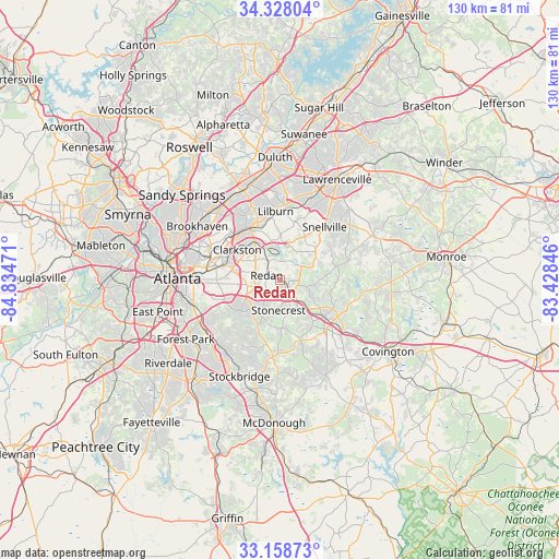
Redan GPS coordinates[2]
33° 44' 43.368" North, 84° 7' 53.688" West
| Map corner | latitude | longitude |
|---|---|---|
| Upper-left | 34.32804°, | -84.83471° |
| Center: | 33.74538°, | -84.13158° |
| Lower-right: | 33.15873°, | -83.42846° |
| Map W x H: | 130×130 km | = 80.8×80.8mi |
| max Lat: | 71.29058° ⇑81.8% North |
| Redan: | 33.74538° |
| min Lat: | ⇓18.2% South 19.06759° |
| min Long | Redan | max Long |
| -171.73463° | -84.13158° | -66.98998° |
| W 58.9%⇐ | ⇒41.1% E |
Elevation
Elevation of Redan is 303 m = 994 ft, and this is 8.2 m = 27 ft above average elevation for this country.
| Max E: |
3189 m = 10463 ft | 26.7% |
| Redan | 303 m 994 ft | |
| Avg. | 294.8 m = 967 ft | |
Min E: |
-60 m = -197 ft | 73.3% |
See also: United States elevation on elevation.city.
Geographical zone
Redan is located in North temperate zone (between Tropic of Cancer and the Arctic Circle). Distance of this Northern Tropic circle is 1146.2 km =712.2 mi to South.| Distance of | km | miles | from Redan |
|---|---|---|---|
| North Pole | 6254.9 | 3886.6 | to North |
| Arctic Circle | 3649 | 2267.4 | to North |
| Tropic Cancer | 1146.2 | 712.2 | to South |
| Equator | 3752.1 | 2331.4 | to South |


Nearby cities:
15 places around Redan: (largest is in red/bold)
• Avondale Estates
12.9 km =8 mi,  283°
283°
• Belvedere Park
12.6 km =7.8 mi,  274°
274°
• Candler-McAfee
13.2 km =8.2 mi,  260°
260°
• Clarkston
12.3 km =7.6 mi,  305°
305°
• Conyers
13.6 km =8.5 mi,  129°
129°
• Lakeview Estates
10.2 km =6.3 mi,  114°
114°
• Lithonia
4.4 km =2.7 mi,  146°
146°
• Mountain Park
11 km =6.8 mi,  1°
1°
• Panthersville
13.6 km =8.5 mi,  251°
251°
• Pine Lake
8.7 km =5.4 mi, 307°
• Pine Mountain
7.9 km =4.9 mi,  168°
168°
• Scottdale
13.2 km =8.2 mi,  291°
291°
• Stone Mountain
7.8 km =4.8 mi,  332°
332°
• Stonecrest
4.1 km =2.5 mi,  184°
184°
• Tucker
14.5 km =9 mi, 326°
Sources, notices
• [Note1] Compared only with cities in United States existing in our database
• [Src1] Map data: © OpenStreetMap contributors (CC-BY-SA)
• [Src2] Other city data from geonames.org with taken over terms of usage.
• [Src3] Geographical zone / Annual Mean Temperature by Robert A. Rohde @ Wikipedia
