Grantville geodata
Grantville (Georgia) is a populated place; located in United States in America/New_York (GMT-4) time zone. With population of 3,183 people, there are 9328 cities with bigger population in this country. Compared to other cities in United States, 84.2% of cities are located further ↑North; 56.3% of cities are located further ←West and 66.1% of cities have lower elevation than Grantville. Note1


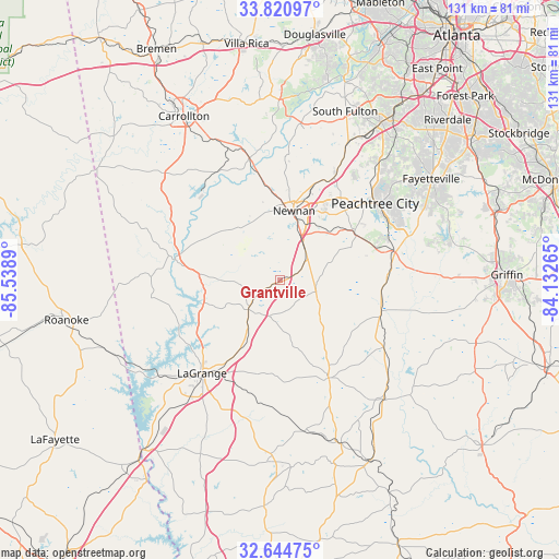
Grantville GPS coordinates[2]
33° 14' 5.424" North, 84° 50' 8.772" West
| Map corner | latitude | longitude |
|---|---|---|
| Upper-left | 33.82097°, | -85.5389° |
| Center: | 33.23484°, | -84.83577° |
| Lower-right: | 32.64475°, | -84.13265° |
| Map W x H: | 130.8×130.8 km | = 81.3×81.3mi |
| max Lat: | 71.29058° ⇑84.2% North |
| Grantville: | 33.23484° |
| min Lat: | ⇓15.8% South 19.06759° |
| min Long | Grantville | max Long |
| -171.73463° | -84.83577° | -66.98998° |
| W 56.3%⇐ | ⇒43.7% E |
Elevation
Elevation of Grantville is 267 m = 876 ft, and this is 27.8 m = 91 ft below average elevation for this country.
| Max E: |
3189 m = 10463 ft | 33.9% |
| Avg. | 294.8 m = 967 ft | |
| Grantville | 267 m = 876 ft | |
Min E: |
-60 m = -197 ft | 66.1% |
See also: United States elevation on elevation.city.
Geographical zone
Grantville is located in North temperate zone (between Tropic of Cancer and the Arctic Circle). Distance of this Northern Tropic circle is 1089.4 km =676.9 mi to South.| Distance of | km | miles | from Grantville |
|---|---|---|---|
| North Pole | 6311.7 | 3921.9 | to North |
| Arctic Circle | 3705.8 | 2302.7 | to North |
| Tropic Cancer | 1089.4 | 676.9 | to South |
| Equator | 3695.4 | 2296.2 | to South |


Nearby cities:
15 places around Grantville: (largest is in red/bold)
• Brooks
35.5 km =22.1 mi,  79°
79°
• Chattahoochee Hills
35.8 km =22.2 mi,  11°
11°
• East Newnan
14 km =8.7 mi,  23°
23°
• Franklin
24.8 km =15.4 mi,  281°
281°
• Greenville
25.6 km =15.9 mi,  153°
153°
• Hogansville
10.1 km =6.3 mi,  227°
227°
• LaGrange
28.4 km =17.6 mi,  219°
219°
• Luthersville
8.9 km =5.5 mi,  107°
107°
• Newnan
16.6 km =10.3 mi, 11°
• Palmetto
35 km =21.7 mi,  26°
26°
• Peachtree City
28.7 km =17.8 mi,  51°
51°
• Senoia
27.3 km =17 mi,  74°
74°
• Tyrone
34.4 km =21.4 mi,  40°
40°
• Whitesburg
29.7 km =18.5 mi,  345°
345°
• Woodbury
36.5 km =22.7 mi,  139°
139°
Sources, notices
• [Note1] Compared only with cities in United States existing in our database
• [Src1] Map data: © OpenStreetMap contributors (CC-BY-SA)
• [Src2] Other city data from geonames.org with taken over terms of usage.
• [Src3] Geographical zone / Annual Mean Temperature by Robert A. Rohde @ Wikipedia
