Soperton geodata
Soperton (Georgia) is a seat of a second-order administrative division; located in United States in America/New_York (GMT-4) time zone. With population of 3,087 people, there are 9486 cities with bigger population in this country. Compared to other cities in United States, 87.6% of cities are located further ↑North; 63.4% of cities are located further ←West and 71.3% of cities have higher elevation than Soperton. Note1


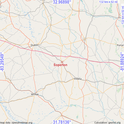
Soperton GPS coordinates[2]
32° 22' 37.632" North, 82° 35' 32.496" West
| Map corner | latitude | longitude |
|---|---|---|
| Upper-left | 32.96898°, | -83.29549° |
| Center: | 32.37712°, | -82.59236° |
| Lower-right: | 31.78136°, | -81.88924° |
| Map W x H: | 132.1×132.1 km | = 82.1×82.1mi |
| max Lat: | 71.29058° ⇑87.6% North |
| Soperton: | 32.37712° |
| min Lat: | ⇓12.4% South 19.06759° |
| min Long | Soperton | max Long |
| -171.73463° | -82.59236° | -66.98998° |
| W 63.4%⇐ | ⇒36.6% E |
Elevation
Elevation of Soperton is 93 m = 305 ft, and this is 201.8 m = 662 ft below average elevation for this country.
| Max E: |
3189 m = 10463 ft | 71.3% |
| Avg. | 294.8 m = 967 ft | |
| Soperton | 93 m = 305 ft | |
Min E: |
-60 m = -197 ft | 28.7% |
See also: United States elevation on elevation.city.
Geographical zone
Soperton is located in North temperate zone (between Tropic of Cancer and the Arctic Circle). Distance of this Northern Tropic circle is 994.1 km =617.7 mi to South.| Distance of | km | miles | from Soperton |
|---|---|---|---|
| North Pole | 6407.1 | 3981.2 | to North |
| Arctic Circle | 3801.2 | 2362 | to North |
| Tropic Cancer | 994.1 | 617.7 | to South |
| Equator | 3600 | 2236.9 | to South |


Nearby cities:
15 places around Soperton: (largest is in red/bold)
• Adrian
17.1 km =10.6 mi,  0°
0°
• Ailey
21.2 km =13.2 mi,  173°
173°
• Alamo
31 km =19.3 mi,  214°
214°
• Cadwell
42.4 km =26.3 mi,  264°
264°
• Dexter
44.4 km =27.6 mi,  277°
277°
• Dublin
34.4 km =21.4 mi,  301°
301°
• East Dublin
32.4 km =20.1 mi,  305°
305°
• Glenwood
23.1 km =14.4 mi,  198°
198°
• Lyons
31.9 km =19.8 mi,  127°
127°
• Mount Vernon
22.1 km =13.7 mi,  180°
180°
• Stillmore
36.1 km =22.4 mi,  78°
78°
• Swainsboro
34.5 km =21.4 mi,  44°
44°
• Uvalda
38.8 km =24.1 mi, 168°
• Vidalia
24.4 km =15.2 mi,  136°
136°
• Wrightsville
40.9 km =25.4 mi,  343°
343°
Sources, notices
• [Note1] Compared only with cities in United States existing in our database
• [Src1] Map data: © OpenStreetMap contributors (CC-BY-SA)
• [Src2] Other city data from geonames.org with taken over terms of usage.
• [Src3] Geographical zone / Annual Mean Temperature by Robert A. Rohde @ Wikipedia
