Dublin geodata
Dublin (Georgia) is a seat of a second-order administrative division; located in United States in America/New_York (GMT-4) time zone. With population of 16,197 people, there are 3029 cities with bigger population in this country. Compared to other cities in United States, 86.9% of cities are located further ↑North; 62.3% of cities are located further ←West and 74.7% of cities have higher elevation than Dublin. Note1


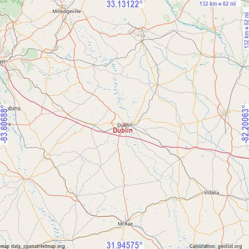
Dublin GPS coordinates[2]
32° 32' 25.584" North, 82° 54' 13.5" West
| Map corner | latitude | longitude |
|---|---|---|
| Upper-left | 33.13122°, | -83.60688° |
| Center: | 32.54044°, | -82.90375° |
| Lower-right: | 31.94575°, | -82.20063° |
| Map W x H: | 131.8×131.8 km | = 81.9×81.9mi |
| max Lat: | 71.29058° ⇑86.9% North |
| Dublin: | 32.54044° |
| min Lat: | ⇓13.1% South 19.06759° |
| min Long | Dublin | max Long |
| -171.73463° | -82.90375° | -66.98998° |
| W 62.3%⇐ | ⇒37.7% E |
Elevation
Elevation of Dublin is 73 m = 240 ft, and this is 221.8 m = 728 ft below average elevation for this country.
| Max E: |
3189 m = 10463 ft | 74.7% |
| Avg. | 294.8 m = 967 ft | |
| Dublin | 73 m = 240 ft | |
Min E: |
-60 m = -197 ft | 25.3% |
See also: United States elevation on elevation.city.
Geographical zone
Dublin is located in North temperate zone (between Tropic of Cancer and the Arctic Circle). Distance of this Northern Tropic circle is 1012.2 km =629 mi to South.| Distance of | km | miles | from Dublin |
|---|---|---|---|
| North Pole | 6388.9 | 3969.9 | to North |
| Arctic Circle | 3783 | 2350.6 | to North |
| Tropic Cancer | 1012.2 | 629 | to South |
| Equator | 3618.2 | 2248.2 | to South |


Nearby cities:
15 places around Dublin: (largest is in red/bold)
• Adrian
29.5 km =18.3 mi,  92°
92°
• Alamo
45.3 km =28.1 mi,  164°
164°
• Cadwell
25.8 km =16 mi,  210°
210°
• Chester
28.5 km =17.7 mi,  235°
235°
• Cochran
45.6 km =28.3 mi,  248°
248°
• Dexter
19 km =11.8 mi,  230°
230°
• Dudley
15.6 km =9.7 mi,  270°
270°
• East Dublin
3.1 km =1.9 mi,  73°
73°
• Glenwood
45.7 km =28.4 mi,  151°
151°
• Irwinton
39.2 km =24.4 mi,  320°
320°
• Jeffersonville
44.6 km =27.7 mi,  291°
291°
• McIntyre
43.3 km =26.9 mi, 321°
• Soperton
34.4 km =21.4 mi,  121°
121°
• Tennille
44.8 km =27.8 mi,  11°
11°
• Wrightsville
27.2 km =16.9 mi,  39°
39°
Sources, notices
• [Note1] Compared only with cities in United States existing in our database
• [Src1] Map data: © OpenStreetMap contributors (CC-BY-SA)
• [Src2] Other city data from geonames.org with taken over terms of usage.
• [Src3] Geographical zone / Annual Mean Temperature by Robert A. Rohde @ Wikipedia
