Villa Rica geodata
Villa Rica (Georgia) is a populated place; located in United States in America/New_York (GMT-4) time zone. With population of 14,904 people, there are 3257 cities with bigger population in this country. Compared to other cities in United States, 81.9% of cities are located further ↑North; 56.1% of cities are located further ←West and 79.6% of cities have lower elevation than Villa Rica. Note1


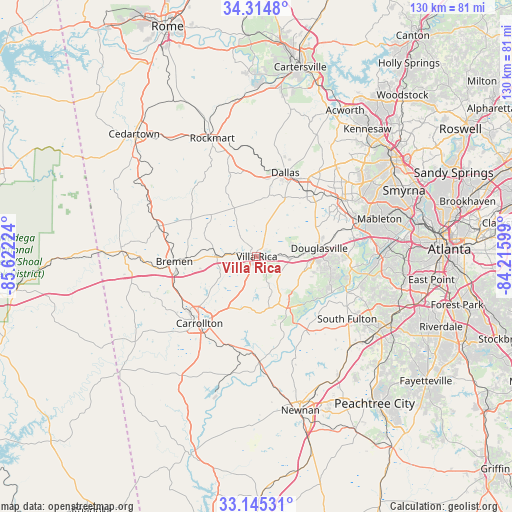
Villa Rica GPS coordinates[2]
33° 43' 55.38" North, 84° 55' 8.796" West
| Map corner | latitude | longitude |
|---|---|---|
| Upper-left | 34.3148°, | -85.62224° |
| Center: | 33.73205°, | -84.91911° |
| Lower-right: | 33.14531°, | -84.21599° |
| Map W x H: | 130×130 km | = 80.8×80.8mi |
| max Lat: | 71.29058° ⇑81.9% North |
| Villa Rica: | 33.73205° |
| min Lat: | ⇓18.1% South 19.06759° |
| min Long | Villa Rica | max Long |
| -171.73463° | -84.91911° | -66.98998° |
| W 56.1%⇐ | ⇒43.9% E |
Elevation
Elevation of Villa Rica is 349 m = 1145 ft, and this is 54.2 m = 178 ft above average elevation for this country.
| Max E: |
3189 m = 10463 ft | 20.4% |
| Villa Rica | 349 m 1145 ft | |
| Avg. | 294.8 m = 967 ft | |
Min E: |
-60 m = -197 ft | 79.6% |
See also: United States elevation on elevation.city.
Geographical zone
Villa Rica is located in North temperate zone (between Tropic of Cancer and the Arctic Circle). Distance of this Northern Tropic circle is 1144.7 km =711.3 mi to South.| Distance of | km | miles | from Villa Rica |
|---|---|---|---|
| North Pole | 6256.4 | 3887.5 | to North |
| Arctic Circle | 3650.5 | 2268.3 | to North |
| Tropic Cancer | 1144.7 | 711.3 | to South |
| Equator | 3750.7 | 2330.6 | to South |


Nearby cities:
15 places around Villa Rica: (largest is in red/bold)
• Austell
27.8 km =17.3 mi,  71°
71°
• Bremen
21 km =13 mi,  266°
266°
• Buchanan
26.1 km =16.2 mi,  287°
287°
• Carrollton
22.3 km =13.9 mi,  220°
220°
• Chattahoochee Hills
25 km =15.5 mi,  143°
143°
• Dallas
22.5 km =14 mi,  18°
18°
• Douglasville
16 km =9.9 mi,  82°
82°
• Hiram
21.6 km =13.4 mi,  42°
42°
• Lithia Springs
24.9 km =15.5 mi, 73°
• Mount Zion
27.1 km =16.8 mi,  246°
246°
• Powder Springs
26 km =16.2 mi,  56°
56°
• Rockmart
32.1 km =19.9 mi,  339°
339°
• Temple
10.5 km =6.5 mi, 273°
• Waco
24.6 km =15.3 mi,  262°
262°
• Whitesburg
26.5 km =16.5 mi,  178°
178°
Sources, notices
• [Note1] Compared only with cities in United States existing in our database
• [Src1] Map data: © OpenStreetMap contributors (CC-BY-SA)
• [Src2] Other city data from geonames.org with taken over terms of usage.
• [Src3] Geographical zone / Annual Mean Temperature by Robert A. Rohde @ Wikipedia
