Bowdon geodata
Bowdon (Georgia) is a populated place; located in United States in America/New_York (GMT-4) time zone. With population of 2,072 people, there are 11713 cities with bigger population in this country. Compared to other cities in United States, 83% of cities are located further ↑North; 55.2% of cities are located further ←West and 77.6% of cities have lower elevation than Bowdon. Note1


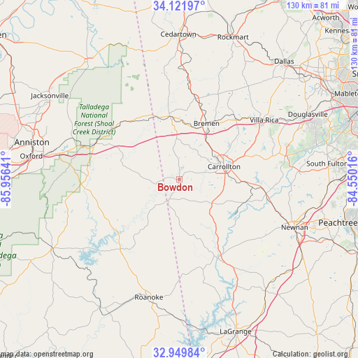
Bowdon GPS coordinates[2]
33° 32' 16.404" North, 85° 15' 11.808" West
| Map corner | latitude | longitude |
|---|---|---|
| Upper-left | 34.12197°, | -85.95641° |
| Center: | 33.53789°, | -85.25328° |
| Lower-right: | 32.94984°, | -84.55016° |
| Map W x H: | 130.3×130.3 km | = 81×81mi |
| max Lat: | 71.29058° ⇑83% North |
| Bowdon: | 33.53789° |
| min Lat: | ⇓17% South 19.06759° |
| min Long | Bowdon | max Long |
| -171.73463° | -85.25328° | -66.98998° |
| W 55.2%⇐ | ⇒44.8% E |
Elevation
Elevation of Bowdon is 333 m = 1093 ft, and this is 38.2 m = 125 ft above average elevation for this country.
| Max E: |
3189 m = 10463 ft | 22.4% |
| Bowdon | 333 m 1093 ft | |
| Avg. | 294.8 m = 967 ft | |
Min E: |
-60 m = -197 ft | 77.6% |
See also: United States elevation on elevation.city.
Geographical zone
Bowdon is located in North temperate zone (between Tropic of Cancer and the Arctic Circle). Distance of this Northern Tropic circle is 1123.1 km =697.9 mi to South.| Distance of | km | miles | from Bowdon |
|---|---|---|---|
| North Pole | 6278 | 3901 | to North |
| Arctic Circle | 3672.1 | 2281.7 | to North |
| Tropic Cancer | 1123.1 | 697.9 | to South |
| Equator | 3729.1 | 2317.2 | to South |


Nearby cities:
15 places around Bowdon: (largest is in red/bold)
• Bremen
22.7 km =14.1 mi,  26°
26°
• Buchanan
30 km =18.6 mi,  11°
11°
• Carrollton
17 km =10.6 mi,  73°
73°
• Choccolocco
43.8 km =27.2 mi,  287°
287°
• Franklin
32.3 km =20.1 mi,  153°
153°
• Heflin
33.3 km =20.7 mi, 291°
• Hollis Crossroads
35.6 km =22.1 mi,  267°
267°
• Mount Zion
12.3 km =7.6 mi, 29°
• Rock Mills
42.2 km =26.2 mi,  184°
184°
• Tallapoosa
23.2 km =14.4 mi,  352°
352°
• Temple
30.1 km =18.7 mi,  42°
42°
• Villa Rica
37.7 km =23.4 mi,  55°
55°
• Waco
19.5 km =12.1 mi,  19°
19°
• Wedowee
33.3 km =20.7 mi,  220°
220°
• Whitesburg
31.8 km =19.8 mi,  98°
98°
Sources, notices
• [Note1] Compared only with cities in United States existing in our database
• [Src1] Map data: © OpenStreetMap contributors (CC-BY-SA)
• [Src2] Other city data from geonames.org with taken over terms of usage.
• [Src3] Geographical zone / Annual Mean Temperature by Robert A. Rohde @ Wikipedia
