Winder geodata
Winder (Georgia) is a seat of a second-order administrative division; located in United States in America/New_York (GMT-4) time zone. With population of 15,447 people, there are 3155 cities with bigger population in this country. Compared to other cities in United States, 80.3% of cities are located further ↑North; 60% of cities are located further ←West and 73.3% of cities have lower elevation than Winder. Note1


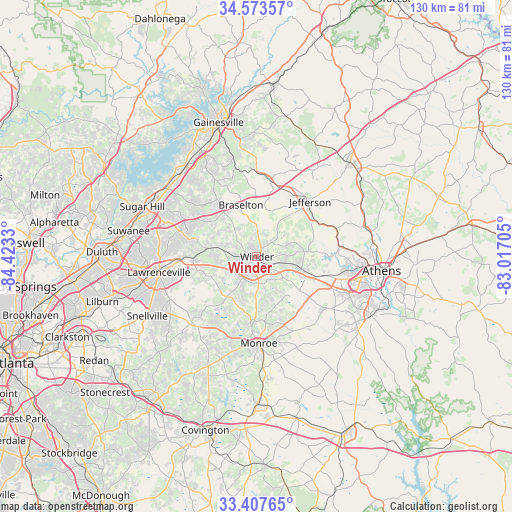
Winder GPS coordinates[2]
33° 59' 33.396" North, 83° 43' 12.612" West
| Map corner | latitude | longitude |
|---|---|---|
| Upper-left | 34.57357°, | -84.4233° |
| Center: | 33.99261°, | -83.72017° |
| Lower-right: | 33.40765°, | -83.01705° |
| Map W x H: | 129.6×129.6 km | = 80.5×80.5mi |
| max Lat: | 71.29058° ⇑80.3% North |
| Winder: | 33.99261° |
| min Lat: | ⇓19.7% South 19.06759° |
| min Long | Winder | max Long |
| -171.73463° | -83.72017° | -66.98998° |
| W 60%⇐ | ⇒40% E |
Elevation
Elevation of Winder is 303 m = 994 ft, and this is 8.2 m = 27 ft above average elevation for this country.
| Max E: |
3189 m = 10463 ft | 26.7% |
| Winder | 303 m 994 ft | |
| Avg. | 294.8 m = 967 ft | |
Min E: |
-60 m = -197 ft | 73.3% |
See also: United States elevation on elevation.city.
Geographical zone
Winder is located in North temperate zone (between Tropic of Cancer and the Arctic Circle). Distance of this Northern Tropic circle is 1173.7 km =729.3 mi to South.| Distance of | km | miles | from Winder |
|---|---|---|---|
| North Pole | 6227.4 | 3869.5 | to North |
| Arctic Circle | 3621.6 | 2250.4 | to North |
| Tropic Cancer | 1173.7 | 729.3 | to South |
| Equator | 3779.6 | 2348.5 | to South |


Nearby cities:
15 places around Winder: (largest is in red/bold)
• Arcade
17.4 km =10.8 mi,  57°
57°
• Auburn
10.2 km =6.3 mi,  283°
283°
• Bethlehem
6.8 km =4.2 mi,  174°
174°
• Bogart
17.8 km =11.1 mi,  105°
105°
• Braselton
13.5 km =8.4 mi,  343°
343°
• Dacula
16.4 km =10.2 mi,  268°
268°
• Grayson
24.3 km =15.1 mi,  243°
243°
• Hoschton
12.2 km =7.6 mi, 341°
• Jefferson
19.4 km =12.1 mi,  44°
44°
• Lawrenceville
25 km =15.5 mi,  260°
260°
• Loganville
23.9 km =14.9 mi,  224°
224°
• Monroe
22 km =13.7 mi,  178°
178°
• North High Shoals
27.5 km =17.1 mi,  134°
134°
• Russell
2.4 km =1.5 mi, 129°
• Statham
11.8 km =7.3 mi, 105°
Sources, notices
• [Note1] Compared only with cities in United States existing in our database
• [Src1] Map data: © OpenStreetMap contributors (CC-BY-SA)
• [Src2] Other city data from geonames.org with taken over terms of usage.
• [Src3] Geographical zone / Annual Mean Temperature by Robert A. Rohde @ Wikipedia
