Statham geodata
Statham (Georgia) is a populated place; located in United States in America/New_York (GMT-4) time zone. With population of 2,624 people, there are 10343 cities with bigger population in this country. Compared to other cities in United States, 80.5% of cities are located further ↑North; 60.4% of cities are located further ←West and 67.4% of cities have lower elevation than Statham. Note1


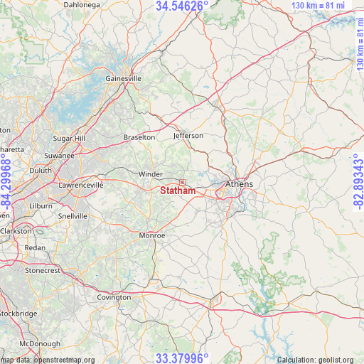
Statham GPS coordinates[2]
33° 57' 54.396" North, 83° 35' 47.58" West
| Map corner | latitude | longitude |
|---|---|---|
| Upper-left | 34.54626°, | -84.29968° |
| Center: | 33.96511°, | -83.59655° |
| Lower-right: | 33.37996°, | -82.89343° |
| Map W x H: | 129.7×129.7 km | = 80.6×80.6mi |
| max Lat: | 71.29058° ⇑80.5% North |
| Statham: | 33.96511° |
| min Lat: | ⇓19.5% South 19.06759° |
| min Long | Statham | max Long |
| -171.73463° | -83.59655° | -66.98998° |
| W 60.4%⇐ | ⇒39.6% E |
Elevation
Elevation of Statham is 273 m = 896 ft, and this is 21.8 m = 72 ft below average elevation for this country.
| Max E: |
3189 m = 10463 ft | 32.6% |
| Avg. | 294.8 m = 967 ft | |
| Statham | 273 m = 896 ft | |
Min E: |
-60 m = -197 ft | 67.4% |
See also: United States elevation on elevation.city.
Geographical zone
Statham is located in North temperate zone (between Tropic of Cancer and the Arctic Circle). Distance of this Northern Tropic circle is 1170.6 km =727.4 mi to South.| Distance of | km | miles | from Statham |
|---|---|---|---|
| North Pole | 6230.5 | 3871.5 | to North |
| Arctic Circle | 3624.6 | 2252.2 | to North |
| Tropic Cancer | 1170.6 | 727.4 | to South |
| Equator | 3776.6 | 2346.7 | to South |


Nearby cities:
15 places around Statham: (largest is in red/bold)
• Arcade
12.9 km =8 mi,  14°
14°
• Athens
20.2 km =12.6 mi,  91°
91°
• Auburn
22 km =13.7 mi,  284°
284°
• Bethlehem
11.4 km =7.1 mi,  251°
251°
• Bogart
6 km =3.7 mi,  107°
107°
• Braselton
22.2 km =13.8 mi,  316°
316°
• Country Club Estates
17.4 km =10.8 mi,  81°
81°
• Hoschton
21.1 km =13.1 mi,  313°
313°
• Jefferson
17 km =10.6 mi, 7°
• Monroe
21.8 km =13.5 mi,  209°
209°
• Nicholson
22.5 km =14 mi,  42°
42°
• North High Shoals
18.2 km =11.3 mi,  152°
152°
• Russell
9.7 km =6 mi, 278°
• Watkinsville
20.7 km =12.9 mi,  123°
123°
• Winder
11.8 km =7.3 mi,  285°
285°
Sources, notices
• [Note1] Compared only with cities in United States existing in our database
• [Src1] Map data: © OpenStreetMap contributors (CC-BY-SA)
• [Src2] Other city data from geonames.org with taken over terms of usage.
• [Src3] Geographical zone / Annual Mean Temperature by Robert A. Rohde @ Wikipedia
