Breese geodata
Breese (Illinois) is a populated place; located in United States in America/Chicago (GMT-5) time zone. With population of 4,506 people, there are 7637 cities with bigger population in this country. Compared to other cities in United States, 58% of cities are located further ↑North; 57.6% of cities are located further →East and 62.9% of cities have higher elevation than Breese. Note1


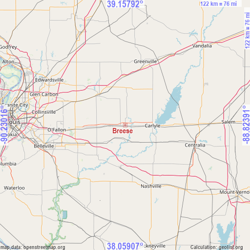
Breese GPS coordinates[2]
38° 36' 38.16" North, 89° 31' 37.308" West
| Map corner | latitude | longitude |
|---|---|---|
| Upper-left | 39.15792°, | -90.23016° |
| Center: | 38.6106°, | -89.52703° |
| Lower-right: | 38.05907°, | -88.82391° |
| Map W x H: | 122.2×122.2 km | = 75.9×75.9mi |
| max Lat: | 71.29058° ⇑58% North |
| Breese: | 38.6106° |
| min Lat: | ⇓42% South 19.06759° |
| min Long | Breese | max Long |
| -171.73463° | -89.52703° | -66.98998° |
| W 42.4%⇐ | ⇒57.6% E |
Elevation
Elevation of Breese is 139 m = 456 ft, and this is 155.8 m = 511 ft below average elevation for this country.
| Max E: |
3189 m = 10463 ft | 62.9% |
| Avg. | 294.8 m = 967 ft | |
| Breese | 139 m = 456 ft | |
Min E: |
-60 m = -197 ft | 37.1% |
See also: United States elevation on elevation.city.
Geographical zone
Breese is located in North temperate zone (between Tropic of Cancer and the Arctic Circle). Distance of this Northern Tropic circle is 1687.2 km =1048.4 mi to South.| Distance of | km | miles | from Breese |
|---|---|---|---|
| North Pole | 5714 | 3550.5 | to North |
| Arctic Circle | 3108.1 | 1931.3 | to North |
| Tropic Cancer | 1687.2 | 1048.4 | to South |
| Equator | 4293.1 | 2667.6 | to South |


Nearby cities:
15 places around Breese: (largest is in red/bold)
• Albers
10.5 km =6.5 mi,  224°
224°
• Aviston
7 km =4.3 mi,  266°
266°
• Bartelso
9.8 km =6.1 mi,  147°
147°
• Beckemeyer
7.9 km =4.9 mi,  94°
94°
• Carlyle
13.4 km =8.3 mi, 90°
• Germantown
6.4 km =4 mi,  188°
188°
• Highland
19 km =11.8 mi,  318°
318°
• Lebanon
24.4 km =15.2 mi, 268°
• New Baden
17.3 km =10.7 mi,  240°
240°
• Okawville
19.7 km =12.2 mi, 185°
• Pierron
18.4 km =11.4 mi,  1°
1°
• Pierron
19.8 km =12.3 mi,  341°
341°
• Pocahontas
24.2 km =15 mi,  357°
357°
• Saint Jacob
23.9 km =14.9 mi,  298°
298°
• Trenton
13.5 km =8.4 mi, 267°
Sources, notices
• [Note1] Compared only with cities in United States existing in our database
• [Src1] Map data: © OpenStreetMap contributors (CC-BY-SA)
• [Src2] Other city data from geonames.org with taken over terms of usage.
• [Src3] Geographical zone / Annual Mean Temperature by Robert A. Rohde @ Wikipedia
