Beckemeyer geodata
Beckemeyer (Illinois) is a populated place; located in United States in America/Chicago (GMT-5) time zone. With population of 1,016 people, there are 16177 cities with bigger population in this country. Compared to other cities in United States, 58.1% of cities are located further ↑North; 57.4% of cities are located further →East and 62.7% of cities have higher elevation than Beckemeyer. Note1


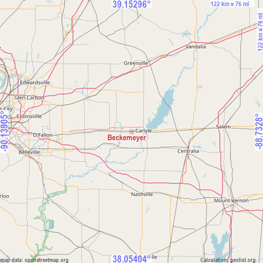
Beckemeyer GPS coordinates[2]
38° 36' 20.16" North, 89° 26' 9.312" West
| Map corner | latitude | longitude |
|---|---|---|
| Upper-left | 39.15296°, | -90.13905° |
| Center: | 38.6056°, | -89.43592° |
| Lower-right: | 38.05404°, | -88.7328° |
| Map W x H: | 122.2×122.2 km | = 75.9×75.9mi |
| max Lat: | 71.29058° ⇑58.1% North |
| Beckemeyer: | 38.6056° |
| min Lat: | ⇓41.9% South 19.06759° |
| min Long | Beckemeyer | max Long |
| -171.73463° | -89.43592° | -66.98998° |
| W 42.6%⇐ | ⇒57.4% E |
Elevation
Elevation of Beckemeyer is 140 m = 459 ft, and this is 154.8 m = 508 ft below average elevation for this country.
| Max E: |
3189 m = 10463 ft | 62.7% |
| Avg. | 294.8 m = 967 ft | |
| Beckemeyer | 140 m = 459 ft | |
Min E: |
-60 m = -197 ft | 37.3% |
See also: United States elevation on elevation.city.
Geographical zone
Beckemeyer is located in North temperate zone (between Tropic of Cancer and the Arctic Circle). Distance of this Northern Tropic circle is 1686.6 km =1048 mi to South.| Distance of | km | miles | from Beckemeyer |
|---|---|---|---|
| North Pole | 5714.5 | 3550.8 | to North |
| Arctic Circle | 3108.6 | 1931.6 | to North |
| Tropic Cancer | 1686.6 | 1048 | to South |
| Equator | 4292.5 | 2667.2 | to South |


Nearby cities:
15 places around Beckemeyer: (largest is in red/bold)
• Albers
16.8 km =10.4 mi,  245°
245°
• Aviston
14.9 km =9.3 mi,  270°
270°
• Bartelso
8.1 km =5 mi,  199°
199°
• Breese
7.9 km =4.9 mi, 274°
• Carlyle
5.5 km =3.4 mi,  84°
84°
• Central City
27.6 km =17.1 mi,  103°
103°
• Germantown
10.6 km =6.6 mi,  237°
237°
• Highland
25.3 km =15.7 mi,  306°
306°
• Hoyleton
23 km =14.3 mi,  142°
142°
• New Baden
24.3 km =15.1 mi, 251°
• Okawville
21.5 km =13.4 mi,  207°
207°
• Pierron
20.4 km =12.7 mi,  338°
338°
• Pierron
24 km =14.9 mi,  324°
324°
• Pocahontas
26.3 km =16.3 mi, 339°
• Trenton
21.4 km =13.3 mi, 270°
Sources, notices
• [Note1] Compared only with cities in United States existing in our database
• [Src1] Map data: © OpenStreetMap contributors (CC-BY-SA)
• [Src2] Other city data from geonames.org with taken over terms of usage.
• [Src3] Geographical zone / Annual Mean Temperature by Robert A. Rohde @ Wikipedia
