Pocahontas geodata
Pocahontas (Illinois) is a populated place; located in United States in America/Chicago (GMT-5) time zone. With population of 745 people, there are 18255 cities with bigger population in this country. Compared to other cities in United States, 56.3% of cities are located further ↑North; 57.6% of cities are located further →East and 56.9% of cities have higher elevation than Pocahontas. Note1


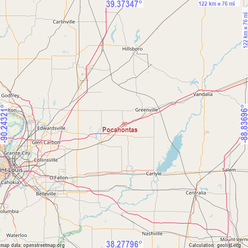
Pocahontas GPS coordinates[2]
38° 49' 40.152" North, 89° 32' 24.288" West
| Map corner | latitude | longitude |
|---|---|---|
| Upper-left | 39.37347°, | -90.24321° |
| Center: | 38.82782°, | -89.54008° |
| Lower-right: | 38.27796°, | -88.83696° |
| Map W x H: | 121.8×121.8 km | = 75.7×75.7mi |
| max Lat: | 71.29058° ⇑56.3% North |
| Pocahontas: | 38.82782° |
| min Lat: | ⇓43.7% South 19.06759° |
| min Long | Pocahontas | max Long |
| -171.73463° | -89.54008° | -66.98998° |
| W 42.4%⇐ | ⇒57.6% E |
Elevation
Elevation of Pocahontas is 171 m = 561 ft, and this is 123.8 m = 406 ft below average elevation for this country.
| Max E: |
3189 m = 10463 ft | 56.9% |
| Avg. | 294.8 m = 967 ft | |
| Pocahontas | 171 m = 561 ft | |
Min E: |
-60 m = -197 ft | 43.1% |
See also: United States elevation on elevation.city.
Geographical zone
Pocahontas is located in North temperate zone (between Tropic of Cancer and the Arctic Circle). Distance of this Northern Tropic circle is 1711.3 km =1063.4 mi to South.| Distance of | km | miles | from Pocahontas |
|---|---|---|---|
| North Pole | 5689.8 | 3535.5 | to North |
| Arctic Circle | 3083.9 | 1916.2 | to North |
| Tropic Cancer | 1711.3 | 1063.4 | to South |
| Equator | 4317.2 | 2682.6 | to South |


Nearby cities:
15 places around Pocahontas: (largest is in red/bold)
• Alhambra
17.9 km =11.1 mi,  292°
292°
• Aviston
25.3 km =15.7 mi,  193°
193°
• Beckemeyer
26.3 km =16.3 mi,  159°
159°
• Breese
24.2 km =15 mi,  177°
177°
• Carlyle
28.2 km =17.5 mi,  148°
148°
• Greenville
13.1 km =8.1 mi,  56°
56°
• Hamel
27.3 km =17 mi,  284°
284°
• Highland
15 km =9.3 mi,  229°
229°
• Livingston
24.8 km =15.4 mi,  308°
308°
• Marine
21.1 km =13.1 mi,  257°
257°
• Mulberry Grove
25.8 km =16 mi,  65°
65°
• Pierron
6 km =3.7 mi, 163°
• Pierron
7.3 km =4.5 mi,  223°
223°
• Saint Jacob
23.5 km =14.6 mi,  237°
237°
• Trenton
27.6 km =17.1 mi,  206°
206°
Sources, notices
• [Note1] Compared only with cities in United States existing in our database
• [Src1] Map data: © OpenStreetMap contributors (CC-BY-SA)
• [Src2] Other city data from geonames.org with taken over terms of usage.
• [Src3] Geographical zone / Annual Mean Temperature by Robert A. Rohde @ Wikipedia
