Centralia geodata
Centralia (Illinois) is a populated place; located in United States in America/Chicago (GMT-5) time zone. With population of 12,655 people, there are 3743 cities with bigger population in this country. Compared to other cities in United States, 58.6% of cities are located further ↑North; 56.6% of cities are located further →East and 60.7% of cities have higher elevation than Centralia. Note1


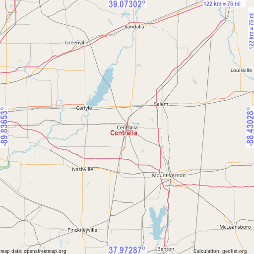
Centralia GPS coordinates[2]
38° 31' 30.18" North, 89° 8' 0.24" West
| Map corner | latitude | longitude |
|---|---|---|
| Upper-left | 39.07302°, | -89.83653° |
| Center: | 38.52505°, | -89.1334° |
| Lower-right: | 37.97287°, | -88.43028° |
| Map W x H: | 122.3×122.3 km | = 76×76mi |
| max Lat: | 71.29058° ⇑58.6% North |
| Centralia: | 38.52505° |
| min Lat: | ⇓41.4% South 19.06759° |
| min Long | Centralia | max Long |
| -171.73463° | -89.1334° | -66.98998° |
| W 43.4%⇐ | ⇒56.6% E |
Elevation
Elevation of Centralia is 151 m = 495 ft, and this is 143.8 m = 472 ft below average elevation for this country.
| Max E: |
3189 m = 10463 ft | 60.7% |
| Avg. | 294.8 m = 967 ft | |
| Centralia | 151 m = 495 ft | |
Min E: |
-60 m = -197 ft | 39.3% |
See also: United States elevation on elevation.city.
Geographical zone
Centralia is located in North temperate zone (between Tropic of Cancer and the Arctic Circle). Distance of this Northern Tropic circle is 1677.7 km =1042.5 mi to South.| Distance of | km | miles | from Centralia |
|---|---|---|---|
| North Pole | 5723.5 | 3556.4 | to North |
| Arctic Circle | 3117.6 | 1937.2 | to North |
| Tropic Cancer | 1677.7 | 1042.5 | to South |
| Equator | 4283.6 | 2661.7 | to South |


Nearby cities:
15 places around Centralia: (largest is in red/bold)
• Ashley
22.3 km =13.9 mi,  192°
192°
• Bartelso
29 km =18 mi,  272°
272°
• Beckemeyer
27.8 km =17.3 mi,  288°
288°
• Carlyle
22.9 km =14.2 mi, 294°
• Central City
2.7 km =1.7 mi,  11°
11°
• Hoyleton
15.4 km =9.6 mi,  232°
232°
• Irvington
9.9 km =6.2 mi,  195°
195°
• Mount Vernon
30.6 km =19 mi,  139°
139°
• Nashville
29.5 km =18.3 mi, 226°
• Odin
12.4 km =7.7 mi,  34°
34°
• Patoka
25.8 km =16 mi, 7°
• Salem
19.9 km =12.4 mi,  55°
55°
• Sandoval
10.2 km =6.3 mi, 9°
• Wamac
1.9 km =1.2 mi, 199°
• Woodlawn
23.4 km =14.5 mi,  157°
157°
Sources, notices
• [Note1] Compared only with cities in United States existing in our database
• [Src1] Map data: © OpenStreetMap contributors (CC-BY-SA)
• [Src2] Other city data from geonames.org with taken over terms of usage.
• [Src3] Geographical zone / Annual Mean Temperature by Robert A. Rohde @ Wikipedia
