Jonesboro geodata
Jonesboro (Illinois) is a seat of a second-order administrative division; located in United States in America/Chicago (GMT-5) time zone. With population of 1,768 people, there are 12672 cities with bigger population in this country. Compared to other cities in United States, 64.2% of cities are located further ↑North; 56.9% of cities are located further →East and 56.2% of cities have higher elevation than Jonesboro. Note1


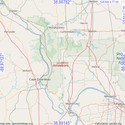
Jonesboro GPS coordinates[2]
37° 27' 6.192" North, 89° 16' 5.304" West
| Map corner | latitude | longitude |
|---|---|---|
| Upper-left | 38.00782°, | -89.97127° |
| Center: | 37.45172°, | -89.26814° |
| Lower-right: | 36.89145°, | -88.56502° |
| Map W x H: | 124.1×124.1 km | = 77.1×77.1mi |
| max Lat: | 71.29058° ⇑64.2% North |
| Jonesboro: | 37.45172° |
| min Lat: | ⇓35.8% South 19.06759° |
| min Long | Jonesboro | max Long |
| -171.73463° | -89.26814° | -66.98998° |
| W 43.1%⇐ | ⇒56.9% E |
Elevation
Elevation of Jonesboro is 175 m = 574 ft, and this is 119.8 m = 393 ft below average elevation for this country.
| Max E: |
3189 m = 10463 ft | 56.2% |
| Avg. | 294.8 m = 967 ft | |
| Jonesboro | 175 m = 574 ft | |
Min E: |
-60 m = -197 ft | 43.8% |
See also: United States elevation on elevation.city.
Geographical zone
Jonesboro is located in North temperate zone (between Tropic of Cancer and the Arctic Circle). Distance of this Northern Tropic circle is 1558.3 km =968.3 mi to South.| Distance of | km | miles | from Jonesboro |
|---|---|---|---|
| North Pole | 5842.8 | 3630.5 | to North |
| Arctic Circle | 3236.9 | 2011.3 | to North |
| Tropic Cancer | 1558.3 | 968.3 | to South |
| Equator | 4164.2 | 2587.5 | to South |


Nearby cities:
15 places around Jonesboro: (largest is in red/bold)
• Anna
2.1 km =1.3 mi,  62°
62°
• Cape Girardeau
27.4 km =17 mi,  233°
233°
• Carbondale
31 km =19.3 mi,  8°
8°
• Cobden
9 km =5.6 mi, 8°
• Crainville
37.8 km =23.5 mi,  27°
27°
• Dongola
13.5 km =8.4 mi,  138°
138°
• Goreville
28.5 km =17.7 mi,  66°
66°
• Grand Tower
28.1 km =17.5 mi,  313°
313°
• Jackson
36 km =22.4 mi,  257°
257°
• Makanda
19.2 km =11.9 mi,  15°
15°
• Murphysboro
35.3 km =21.9 mi,  350°
350°
• Olive Branch
32.3 km =20.1 mi,  193°
193°
• Scott City
34.6 km =21.5 mi,  220°
220°
• Tamms
24.1 km =15 mi,  180°
180°
• Vienna
32.9 km =20.4 mi,  97°
97°
Sources, notices
• [Note1] Compared only with cities in United States existing in our database
• [Src1] Map data: © OpenStreetMap contributors (CC-BY-SA)
• [Src2] Other city data from geonames.org with taken over terms of usage.
• [Src3] Geographical zone / Annual Mean Temperature by Robert A. Rohde @ Wikipedia
