Harrisburg geodata
Harrisburg (Illinois) is a seat of a second-order administrative division; located in United States in America/Chicago (GMT-5) time zone. With population of 8,891 people, there are 4845 cities with bigger population in this country. Compared to other cities in United States, 63.1% of cities are located further ↑North; 54.9% of cities are located further →East and 66.2% of cities have higher elevation than Harrisburg. Note1
Administrative division(s):
- Level 1: Illinois
- Level 2: Saline County
- Level 3: Township of Harrisburg


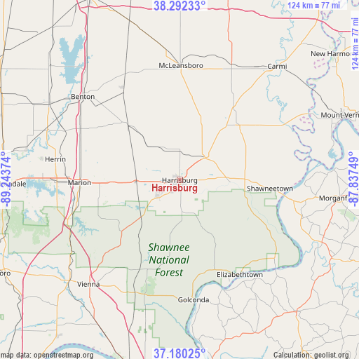
Harrisburg GPS coordinates[2]
37° 44' 18.168" North, 88° 32' 26.196" West
| Map corner | latitude | longitude |
|---|---|---|
| Upper-left | 38.29233°, | -89.24374° |
| Center: | 37.73838°, | -88.54061° |
| Lower-right: | 37.18025°, | -87.83749° |
| Map W x H: | 123.7×123.7 km | = 76.9×76.9mi |
| max Lat: | 71.29058° ⇑63.1% North |
| Harrisburg: | 37.73838° |
| min Lat: | ⇓36.9% South 19.06759° |
| min Long | Harrisburg | max Long |
| -171.73463° | -88.54061° | -66.98998° |
| W 45.1%⇐ | ⇒54.9% E |
Elevation
Elevation of Harrisburg is 122 m = 400 ft, and this is 172.8 m = 567 ft below average elevation for this country.
| Max E: |
3189 m = 10463 ft | 66.2% |
| Avg. | 294.8 m = 967 ft | |
| Harrisburg | 122 m = 400 ft | |
Min E: |
-60 m = -197 ft | 33.8% |
See also: United States elevation on elevation.city.
Geographical zone
Harrisburg is located in North temperate zone (between Tropic of Cancer and the Arctic Circle). Distance of this Northern Tropic circle is 1590.2 km =988.1 mi to South.| Distance of | km | miles | from Harrisburg |
|---|---|---|---|
| North Pole | 5810.9 | 3610.7 | to North |
| Arctic Circle | 3205.1 | 1991.6 | to North |
| Tropic Cancer | 1590.2 | 988.1 | to South |
| Equator | 4196.1 | 2607.3 | to South |


Nearby cities:
15 places around Harrisburg: (largest is in red/bold)
• Carrier Mills
10.1 km =6.3 mi,  233°
233°
• Creal Springs
29.2 km =18.1 mi,  243°
243°
• Eldorado
12.3 km =7.6 mi,  47°
47°
• Elizabethtown
38.6 km =24 mi,  147°
147°
• Equality
17.4 km =10.8 mi,  91°
91°
• Galatia
12.9 km =8 mi,  332°
332°
• Johnston City
35.2 km =21.9 mi,  285°
285°
• Marion
34.5 km =21.4 mi,  268°
268°
• Norris City
32.8 km =20.4 mi,  34°
34°
• Pittsburg
27.5 km =17.1 mi,  278°
278°
• Ridgway
25.5 km =15.8 mi,  74°
74°
• Rosiclare
39 km =24.2 mi, 153°
• Shawneetown
31.3 km =19.4 mi,  95°
95°
• Thompsonville
27.9 km =17.3 mi,  315°
315°
• West Frankfort
38.6 km =24 mi,  297°
297°
Sources, notices
• [Note1] Compared only with cities in United States existing in our database
• [Src1] Map data: © OpenStreetMap contributors (CC-BY-SA)
• [Src2] Other city data from geonames.org with taken over terms of usage.
• [Src3] Geographical zone / Annual Mean Temperature by Robert A. Rohde @ Wikipedia
