Ridgway geodata
Ridgway (Illinois) is a populated place; located in United States in America/Chicago (GMT-5) time zone. With population of 816 people, there are 17663 cities with bigger population in this country. Compared to other cities in United States, 62.7% of cities are located further ↑North; 54% of cities are located further →East and 67.5% of cities have higher elevation than Ridgway. Note1


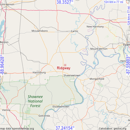
Ridgway GPS coordinates[2]
37° 47' 57.156" North, 88° 15' 40.14" West
| Map corner | latitude | longitude |
|---|---|---|
| Upper-left | 38.3527°, | -88.96428° |
| Center: | 37.79921°, | -88.26115° |
| Lower-right: | 37.24154°, | -87.55803° |
| Map W x H: | 123.5×123.5 km | = 76.7×76.7mi |
| max Lat: | 71.29058° ⇑62.7% North |
| Ridgway: | 37.79921° |
| min Lat: | ⇓37.3% South 19.06759° |
| min Long | Ridgway | max Long |
| -171.73463° | -88.26115° | -66.98998° |
| W 46%⇐ | ⇒54% E |
Elevation
Elevation of Ridgway is 115 m = 377 ft, and this is 179.8 m = 590 ft below average elevation for this country.
| Max E: |
3189 m = 10463 ft | 67.5% |
| Avg. | 294.8 m = 967 ft | |
| Ridgway | 115 m = 377 ft | |
Min E: |
-60 m = -197 ft | 32.5% |
See also: United States elevation on elevation.city.
Geographical zone
Ridgway is located in North temperate zone (between Tropic of Cancer and the Arctic Circle). Distance of this Northern Tropic circle is 1597 km =992.3 mi to South.| Distance of | km | miles | from Ridgway |
|---|---|---|---|
| North Pole | 5804.2 | 3606.6 | to North |
| Arctic Circle | 3198.3 | 1987.3 | to North |
| Tropic Cancer | 1597 | 992.3 | to South |
| Equator | 4202.9 | 2611.6 | to South |


Nearby cities:
15 places around Ridgway: (largest is in red/bold)
• Breckinridge Center
37.3 km =23.2 mi,  110°
110°
• Carmi
33.7 km =20.9 mi,  15°
15°
• Carrier Mills
35.1 km =21.8 mi,  248°
248°
• Eldorado
15.6 km =9.7 mi,  275°
275°
• Elizabethtown
39.5 km =24.5 mi,  185°
185°
• Enfield
34.1 km =21.2 mi,  348°
348°
• Equality
10.2 km =6.3 mi,  224°
224°
• Galatia
30.9 km =19.2 mi, 278°
• Harrisburg
25.5 km =15.8 mi, 254°
• Morganfield
32.9 km =20.4 mi, 113°
• Mount Vernon
35.4 km =22 mi,  65°
65°
• Norris City
21.1 km =13.1 mi,  343°
343°
• Shawneetown
11.6 km =7.2 mi,  145°
145°
• Sturgis
37.2 km =23.1 mi,  139°
139°
• Uniontown
29.2 km =18.1 mi,  95°
95°
Sources, notices
• [Note1] Compared only with cities in United States existing in our database
• [Src1] Map data: © OpenStreetMap contributors (CC-BY-SA)
• [Src2] Other city data from geonames.org with taken over terms of usage.
• [Src3] Geographical zone / Annual Mean Temperature by Robert A. Rohde @ Wikipedia
