Marshall geodata
Marshall (Illinois) is a seat of a second-order administrative division; located in United States in America/Chicago (GMT-5) time zone. With population of 3,880 people, there are 8358 cities with bigger population in this country. Compared to other cities in United States, 51.6% of cities are located further ↑North; 51.4% of cities are located further →East and 51.4% of cities have higher elevation than Marshall. Note1


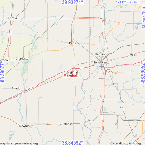
Marshall GPS coordinates[2]
39° 23' 29.148" North, 87° 41' 37.104" West
| Map corner | latitude | longitude |
|---|---|---|
| Upper-left | 39.93271°, | -88.39677° |
| Center: | 39.39143°, | -87.69364° |
| Lower-right: | 38.84592°, | -86.99052° |
| Map W x H: | 120.8×120.8 km | = 75.1×75.1mi |
| max Lat: | 71.29058° ⇑51.6% North |
| Marshall: | 39.39143° |
| min Lat: | ⇓48.4% South 19.06759° |
| min Long | Marshall | max Long |
| -171.73463° | -87.69364° | -66.98998° |
| W 48.6%⇐ | ⇒51.4% E |
Elevation
Elevation of Marshall is 193 m = 633 ft, and this is 101.8 m = 334 ft below average elevation for this country.
| Max E: |
3189 m = 10463 ft | 51.4% |
| Avg. | 294.8 m = 967 ft | |
| Marshall | 193 m = 633 ft | |
Min E: |
-60 m = -197 ft | 48.6% |
See also: United States elevation on elevation.city.
Geographical zone
Marshall is located in North temperate zone (between Tropic of Cancer and the Arctic Circle). Distance of this Northern Tropic circle is 1774 km =1102.3 mi to South.| Distance of | km | miles | from Marshall |
|---|---|---|---|
| North Pole | 5627.1 | 3496.5 | to North |
| Arctic Circle | 3021.3 | 1877.3 | to North |
| Tropic Cancer | 1774 | 1102.3 | to South |
| Equator | 4379.9 | 2721.5 | to South |


Nearby cities:
15 places around Marshall: (largest is in red/bold)
• Ashmore
32.3 km =20.1 mi,  299°
299°
• Casey
27.7 km =17.2 mi,  248°
248°
• Farmersburg
31.2 km =19.4 mi,  120°
120°
• Hutsonville
31.5 km =19.6 mi,  174°
174°
• Kansas
27.7 km =17.2 mi,  310°
310°
• Martinsville
17.3 km =10.7 mi, 249°
• North Terre Haute
32.4 km =20.1 mi,  62°
62°
• Paris
24.4 km =15.2 mi,  359°
359°
• Saint Bernice
38.3 km =23.8 mi,  22°
22°
• Saint Mary-of-the-Woods
23.5 km =14.6 mi, 55°
• Shelburn
35 km =21.7 mi,  132°
132°
• Tecumseh
30.2 km =18.8 mi,  50°
50°
• Terre Haute
25.4 km =15.8 mi,  70°
70°
• West Terre Haute
22.5 km =14 mi, 68°
• Westfield
27 km =16.8 mi,  285°
285°
Sources, notices
• [Note1] Compared only with cities in United States existing in our database
• [Src1] Map data: © OpenStreetMap contributors (CC-BY-SA)
• [Src2] Other city data from geonames.org with taken over terms of usage.
• [Src3] Geographical zone / Annual Mean Temperature by Robert A. Rohde @ Wikipedia
