Paris geodata
Paris (Illinois) is a seat of a second-order administrative division; located in United States in America/Chicago (GMT-5) time zone. With population of 8,432 people, there are 5061 cities with bigger population in this country. Compared to other cities in United States, 50% of cities are located further ↓South; 51.4% of cities are located further →East and 56.1% of cities have lower elevation than Paris. Note1


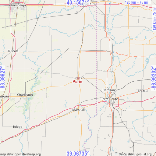
Paris GPS coordinates[2]
39° 36' 40.14" North, 87° 41' 46.104" West
| Map corner | latitude | longitude |
|---|---|---|
| Upper-left | 40.15071°, | -88.39927° |
| Center: | 39.61115°, | -87.69614° |
| Lower-right: | 39.06735°, | -86.99302° |
| Map W x H: | 120.5×120.5 km | = 74.9×74.9mi |
| max Lat: | 71.29058° ⇑50% North |
| Paris: | 39.61115° |
| min Lat: | ⇓50% South 19.06759° |
| min Long | Paris | max Long |
| -171.73463° | -87.69614° | -66.98998° |
| W 48.6%⇐ | ⇒51.4% E |
Elevation
Elevation of Paris is 223 m = 732 ft, and this is 71.8 m = 236 ft below average elevation for this country.
| Max E: |
3189 m = 10463 ft | 43.9% |
| Avg. | 294.8 m = 967 ft | |
| Paris | 223 m = 732 ft | |
Min E: |
-60 m = -197 ft | 56.1% |
See also: United States elevation on elevation.city.
Geographical zone
Paris is located in North temperate zone (between Tropic of Cancer and the Arctic Circle). Distance of this Northern Tropic circle is 1798.4 km =1117.5 mi to South.| Distance of | km | miles | from Paris |
|---|---|---|---|
| North Pole | 5602.7 | 3481.4 | to North |
| Arctic Circle | 2996.8 | 1862.1 | to North |
| Tropic Cancer | 1798.4 | 1117.5 | to South |
| Equator | 4404.3 | 2736.7 | to South |


Nearby cities:
15 places around Paris: (largest is in red/bold)
• Ashmore
29.3 km =18.2 mi,  252°
252°
• Chrisman
21.5 km =13.4 mi,  5°
5°
• Clinton
26 km =16.2 mi,  78°
78°
• Dana
27.8 km =17.3 mi,  38°
38°
• Fairview Park
25.1 km =15.6 mi,  72°
72°
• Kansas
21.8 km =13.5 mi, 252°
• Marshall
24.4 km =15.2 mi,  179°
179°
• North Terre Haute
30.2 km =18.8 mi,  107°
107°
• Oakland
28.7 km =17.8 mi,  279°
279°
• Saint Bernice
18.5 km =11.5 mi,  53°
53°
• Saint Mary-of-the-Woods
22.6 km =14 mi,  119°
119°
• Tecumseh
24.1 km =15 mi,  102°
102°
• Terre Haute
29 km =18 mi, 123°
• West Terre Haute
26.6 km =16.5 mi,  127°
127°
• Westfield
30.9 km =19.2 mi,  236°
236°
Sources, notices
• [Note1] Compared only with cities in United States existing in our database
• [Src1] Map data: © OpenStreetMap contributors (CC-BY-SA)
• [Src2] Other city data from geonames.org with taken over terms of usage.
• [Src3] Geographical zone / Annual Mean Temperature by Robert A. Rohde @ Wikipedia
