Vincennes geodata
Vincennes (Indiana) is a seat of a second-order administrative division; located in United States in America/Indiana/Vincennes (GMT-4) time zone. With population of 18,012 people, there are 2778 cities with bigger population in this country. Compared to other cities in United States, 57.6% of cities are located further ↑North; 50.8% of cities are located further →East and 64.4% of cities have higher elevation than Vincennes. Note1


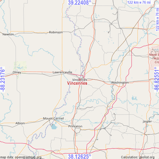
Vincennes GPS coordinates[2]
38° 40' 38.172" North, 87° 31' 43.068" West
| Map corner | latitude | longitude |
|---|---|---|
| Upper-left | 39.22408°, | -88.23176° |
| Center: | 38.67727°, | -87.52863° |
| Lower-right: | 38.12625°, | -86.82551° |
| Map W x H: | 122.1×122.1 km | = 75.9×75.9mi |
| max Lat: | 71.29058° ⇑57.6% North |
| Vincennes: | 38.67727° |
| min Lat: | ⇓42.4% South 19.06759° |
| min Long | Vincennes | max Long |
| -171.73463° | -87.52863° | -66.98998° |
| W 49.2%⇐ | ⇒50.8% E |
Elevation
Elevation of Vincennes is 131 m = 430 ft, and this is 163.8 m = 537 ft below average elevation for this country.
| Max E: |
3189 m = 10463 ft | 64.4% |
| Avg. | 294.8 m = 967 ft | |
| Vincennes | 131 m = 430 ft | |
Min E: |
-60 m = -197 ft | 35.6% |
See also: United States elevation on elevation.city.
Geographical zone
Vincennes is located in North temperate zone (between Tropic of Cancer and the Arctic Circle). Distance of this Northern Tropic circle is 1694.6 km =1053 mi to South.| Distance of | km | miles | from Vincennes |
|---|---|---|---|
| North Pole | 5706.6 | 3545.9 | to North |
| Arctic Circle | 3100.7 | 1926.7 | to North |
| Tropic Cancer | 1694.6 | 1053 | to South |
| Equator | 4300.5 | 2672.2 | to South |


Nearby cities:
15 places around Vincennes: (largest is in red/bold)
• Bicknell
22 km =13.7 mi,  60°
60°
• Bridgeport
20.3 km =12.6 mi,  279°
279°
• Carlisle
34.1 km =21.2 mi,  18°
18°
• Freelandville
28.4 km =17.6 mi,  42°
42°
• Lawrenceville
14.5 km =9 mi,  293°
293°
• Monroe City
16.6 km =10.3 mi,  114°
114°
• Mount Carmel
35.9 km =22.3 mi,  214°
214°
• Oaktown
22.8 km =14.2 mi, 19°
• Palestine
37 km =23 mi,  348°
348°
• Patoka
30.5 km =19 mi,  189°
189°
• Petersburg
29.9 km =18.6 mi,  133°
133°
• Princeton
36 km =22.4 mi, 185°
• Saint Francisville
14 km =8.7 mi,  226°
226°
• Sumner
29.2 km =18.1 mi, 278°
• Washington
31 km =19.3 mi,  93°
93°
Sources, notices
• [Note1] Compared only with cities in United States existing in our database
• [Src1] Map data: © OpenStreetMap contributors (CC-BY-SA)
• [Src2] Other city data from geonames.org with taken over terms of usage.
• [Src3] Geographical zone / Annual Mean Temperature by Robert A. Rohde @ Wikipedia
