Greenfield geodata
Greenfield (Indiana) is a seat of a second-order administrative division; located in United States in America/Indiana/Indianapolis (GMT-4) time zone. With population of 21,497 people, there are 2351 cities with bigger population in this country. Compared to other cities in United States, 51.4% of cities are located further ↓South; 53.5% of cities are located further ←West and 67.4% of cities have lower elevation than Greenfield. Note1


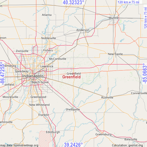
Greenfield GPS coordinates[2]
39° 47' 6.144" North, 85° 46' 9.912" West
| Map corner | latitude | longitude |
|---|---|---|
| Upper-left | 40.32323°, | -86.47255° |
| Center: | 39.78504°, | -85.76942° |
| Lower-right: | 39.2426°, | -85.0663° |
| Map W x H: | 120.2×120.2 km | = 74.7×74.7mi |
| max Lat: | 71.29058° ⇑48.6% North |
| Greenfield: | 39.78504° |
| min Lat: | ⇓51.4% South 19.06759° |
| min Long | Greenfield | max Long |
| -171.73463° | -85.76942° | -66.98998° |
| W 53.5%⇐ | ⇒46.5% E |
Elevation
Elevation of Greenfield is 273 m = 896 ft, and this is 21.8 m = 72 ft below average elevation for this country.
| Max E: |
3189 m = 10463 ft | 32.6% |
| Avg. | 294.8 m = 967 ft | |
| Greenfield | 273 m = 896 ft | |
Min E: |
-60 m = -197 ft | 67.4% |
See also: United States elevation on elevation.city.
Geographical zone
Greenfield is located in North temperate zone (between Tropic of Cancer and the Arctic Circle). Distance of this Northern Tropic circle is 1817.8 km =1129.5 mi to South.| Distance of | km | miles | from Greenfield |
|---|---|---|---|
| North Pole | 5583.4 | 3469.4 | to North |
| Arctic Circle | 2977.5 | 1850.1 | to North |
| Tropic Cancer | 1817.8 | 1129.5 | to South |
| Equator | 4423.7 | 2748.8 | to South |


Nearby cities:
15 places around Greenfield: (largest is in red/bold)
• Carthage
17.7 km =11 mi,  107°
107°
• Cumberland
16.1 km =10 mi,  266°
266°
• Fairland
23.6 km =14.7 mi,  199°
199°
• Fishers
28.2 km =17.5 mi,  312°
312°
• Fortville
17.7 km =11 mi,  337°
337°
• Ingalls
19.4 km =12.1 mi,  350°
350°
• Knightstown
20.8 km =12.9 mi,  86°
86°
• Lawrence
22.6 km =14 mi,  285°
285°
• Markleville
25.2 km =15.7 mi,  31°
31°
• McCordsville
18.9 km =11.7 mi,  316°
316°
• Morristown
13.8 km =8.6 mi,  153°
153°
• New Palestine
12.4 km =7.7 mi,  235°
235°
• Pendleton
23.7 km =14.7 mi,  4°
4°
• Shirley
20.3 km =12.6 mi,  54°
54°
• Warren Park
24 km =14.9 mi, 269°
Sources, notices
• [Note1] Compared only with cities in United States existing in our database
• [Src1] Map data: © OpenStreetMap contributors (CC-BY-SA)
• [Src2] Other city data from geonames.org with taken over terms of usage.
• [Src3] Geographical zone / Annual Mean Temperature by Robert A. Rohde @ Wikipedia
