Ingalls geodata
Ingalls (Indiana) is a populated place; located in United States in America/Indiana/Indianapolis (GMT-4) time zone. With population of 2,382 people, there are 10898 cities with bigger population in this country. Compared to other cities in United States, 53.1% of cities are located further ↓South; 53.4% of cities are located further ←West and 65.2% of cities have lower elevation than Ingalls. Note1


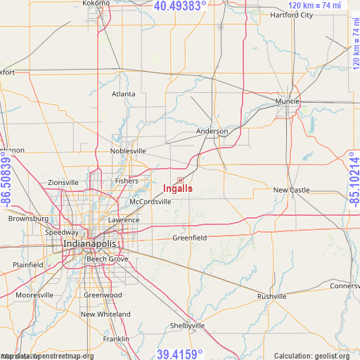
Ingalls GPS coordinates[2]
39° 57' 25.164" North, 85° 48' 18.936" West
| Map corner | latitude | longitude |
|---|---|---|
| Upper-left | 40.49383°, | -86.50839° |
| Center: | 39.95699°, | -85.80526° |
| Lower-right: | 39.4159°, | -85.10214° |
| Map W x H: | 119.9×119.9 km | = 74.5×74.5mi |
| max Lat: | 71.29058° ⇑46.9% North |
| Ingalls: | 39.95699° |
| min Lat: | ⇓53.1% South 19.06759° |
| min Long | Ingalls | max Long |
| -171.73463° | -85.80526° | -66.98998° |
| W 53.4%⇐ | ⇒46.6% E |
Elevation
Elevation of Ingalls is 263 m = 863 ft, and this is 31.8 m = 104 ft below average elevation for this country.
| Max E: |
3189 m = 10463 ft | 34.8% |
| Avg. | 294.8 m = 967 ft | |
| Ingalls | 263 m = 863 ft | |
Min E: |
-60 m = -197 ft | 65.2% |
See also: United States elevation on elevation.city.
Geographical zone
Ingalls is located in North temperate zone (between Tropic of Cancer and the Arctic Circle). Distance of this Northern Tropic circle is 1836.9 km =1141.4 mi to South.| Distance of | km | miles | from Ingalls |
|---|---|---|---|
| North Pole | 5564.3 | 3457.5 | to North |
| Arctic Circle | 2958.4 | 1838.3 | to North |
| Tropic Cancer | 1836.9 | 1141.4 | to South |
| Equator | 4442.8 | 2760.6 | to South |


Nearby cities:
15 places around Ingalls: (largest is in red/bold)
• Anderson
19.6 km =12.2 mi,  32°
32°
• Chesterfield
24.8 km =15.4 mi,  45°
45°
• Cumberland
23.9 km =14.9 mi,  212°
212°
• Edgewood
17.4 km =10.8 mi,  20°
20°
• Fishers
17.8 km =11.1 mi,  269°
269°
• Fortville
4.6 km =2.9 mi,  232°
232°
• Greenfield
19.4 km =12.1 mi,  170°
170°
• Lapel
12.9 km =8 mi,  343°
343°
• Lawrence
22.9 km =14.2 mi, 234°
• Markleville
16.4 km =10.2 mi,  81°
81°
• McCordsville
11.4 km =7.1 mi,  241°
241°
• Middletown
25.4 km =15.8 mi,  63°
63°
• Noblesville
19.9 km =12.4 mi,  299°
299°
• Pendleton
6.7 km =4.2 mi, 47°
• Shirley
20.8 km =12.9 mi,  110°
110°
Sources, notices
• [Note1] Compared only with cities in United States existing in our database
• [Src1] Map data: © OpenStreetMap contributors (CC-BY-SA)
• [Src2] Other city data from geonames.org with taken over terms of usage.
• [Src3] Geographical zone / Annual Mean Temperature by Robert A. Rohde @ Wikipedia
